Was the disappearance of MH370 a CIA false flag operation?
DISCLAIMER: The following is just a theoretical opinion, a theory, based on my own knowledge of events, news reports, factual evidence, and my own research. I do not expect people to read this as a factual report but simply as my own personal theoretical opinion.

Two American ex-Navy Seals, who worked for the maritime security company Trident Group, assigned to guard the ship Maersk Alabama and it's cargo from pirates, Jeffrey Reynolds and Mark Kennedy, were found dead in a cabin on-board the ship on February 18th, 2014. Both men were reported to have died of respiratory failure and possible heart attacks. A local pathologist concluded that Mr. Reynolds’s and Mr. Kennedy’s heart failures “had been as a result of a combination of heroin and alcohol consumption,” the police said in a statement.
 |
|
| Mark Kennedy Jeffery Reynolds |
Read this interesting blog entitled the "The Drone Papers" The Drone Papers

It tells me, that there is a whole SHITLOAD of sensitive valuable drone technology in Africa, and probably the Somalia Pirates and the Chinese knew this. This news report, Sun Sentinel Report shows us how much the Chinese are willing to pay to get their hands on US drone technology and how much of significant threat this would be to US national security if they did.
Here is a video of a USAF classified anti-gravity drone. Is this the kind of drone technology the Chinese may have been interested in to gain knowledge of and wanted to steal this technology from the US Government?
The Theory
The Chinese and Somalia pirates in Africa were well aware of these drone bases in Seychelles. and elsewhere in Africa, and knew about the valuable sensitive mobile drone command and control cargo being shipped to these drone bases on-board the Maersk Alabama thanks to Chinese Intelligence who were eagerly interested in getting their hands on such hardware and purchasing it. What the pirates wanted was money and what the Chinese wanted was the technology. The Somalia pirates knew that the Chinese would pay big bucks for this technology so they launched a plan to get on-board that ship and steal this valuable drone technology.Chinese hackers managed to hack into US shipping company servers and were able to find out what military cargo was being shipped on which US vessels. I believe this is why and how the Maersk Alabama was targeted. The Chinese hackers were able to find out what drone cargo, in which containers, was on-board the Maersk and they passed this info onto the Somalia pirates. Read this security report.
The pirates devised a plan to use two woman prostitutes to lure Kennedy and Reynolds, who were getting drunk and gambling at a casino that evening, back to the ship for a private party and kill them. Read this article about that fateful night: New York Times Report
The woman went back to the ship with Reynolds and Kennedy, to their private cabin, and waited until the men passed out, from drinking all night, and then injected them both with a lethal dose of heroin leaving the syringes in their hands to make it look like they injected themselves. Once they were both incapacitated the woman let onto the boat other pirates who went onto the ship and searched the containers for the mobile drone command and control cargo using bolt cutters to open up the containers. Most of the other crew members were asleep at this time and only a few were on deck at the front of the boat and did not notice any strange activity. Once they located the drone hardware, that they were after, the pirates then unloaded the crates by ropes off the back of the ship and onto a waiting cargo truck. The pirates then left the ship, along with the two prostitutes, and made off with the cargo.
The stolen drone hardware was then driven to a pirate cargo ship and loaded on-board then transported to Malaysia arriving there at end of February 2014, where Chinese Defense Intelligence officers purchased the hardware and transported it to the Chinese Embassy in Kuala Lumpur. At the Chinese Embassy were a team of 20 scientists and engineers from the company Freescale Technologies, who were working for Chinese Defense Intelligence, waiting for the arrival of the drone cargo to immediately begin downloading the software and back engineering the drone technology. What the Chinese wanted was to be able the hack into America's Global Drone Network and be able to control US drones themselves. The US Government saw this as a major significant threat to their national security.
The Chinese then planned to have the secret cargo transported to Beijing via a commercial carrier. They calculated that this would be least suspicious way to transport the cargo and they figured it was the safest way because the Americans would never harm the passengers. MH370 was the ideal carrier.
The Cover Story
Upon hearing the news of the discovery of the bodies of both Kennedy and Reynolds on-board the Maersk Alabama and the theft of several crates containing a mobile US drone command and control unit the CIA immediately issued a cover story. They needed to keep the fact that US drone technology was stolen a secret so they planted this story in the media to make it look like Kennedy and Reynolds died a tragic death and nothing nefarious happened on the boat. The CIA did not want any publicity about the stolen cargo and instructed the crew not to tell the local authorities about the theft of cargo for it was a classified matter. They immediately started to investigate the incident and would stop at nothing to recapture this cargo.The cover story: CNN Report
If this hardware ended up in the hands of Chinese they could have easily back engineered it's technology and within a few months they would have been able control and disable US drones using their own technology, no way would the US allow this to happen. The US has invested billions of dollars in their drone programs and having a foreign government being able to hack into their drones and use them as possible weapons against the United States would have been seen as a very serious national security threat to both the CIA and US military.
What the Chinese would have wanted more than the hardware was the software contained in the command unit that would give them the signal protocols, encryption methods, and command codes used to control these pilot-less drones which would give them the ability to hack into other US drone systems as well.
Read these articles: America's Secret Empire of Drone Bases The Drone Papers: A fascinating look into the Obama's administration's drone wars and U.S. military’s and CIA's assassination program in Afghanistan, Yemen, and Somalia.
The Cargo
Most US drones are controlled via satellite control from various drone bases located worldwide of which some are located in Nevada and elsewhere in the US and throughout the world including bases in Afghanistan, Seychelles and elsewhere . There are Predator drones that are flown and controlled by US forces from these drone bases using mobile command and control systems that are installed in climate controlled trailers with a satellite up-link, like this one (see photo below). They are used to monitor enemy positions, troop movements, as well as attack enemy targets.
"Malaysian Airlines have now said that the mystery cargo was merely electrical equipment. It
released a statement saying the unspecified freight was actually radio
equipment, despite there being no reference to this in the manifest
released last Thursday." Read this: MH370 Mystery Cargo
The Cover-Up
Why is information pertaining to a commercial airline accident considered classified information within the US Government?This freedom of information request pertaining to information on MH370, submitted by Dr. Orly Taitz in April 2014, was rejected in this letter citing that it was a "classified matter." The only other commercial airline accidents that were classified by the US government, that I am aware of, were the 9/11 attacks. I find this highly suspicious that US Government would classify this information if MH370 was just a pilot suicide or mechanical issue.


How can a military base like Diego Garcia not have seen MH370 on radar?
Diego
Garcia is one of the worlds most heavily guarded top secret military
bases and is equipped with both microwave radar and over the horizon
radar (OTH) The microwave radar is a SPS-49 radar and has a 360 degree
range of approximately 250nm (474Km). The OTH radar is a long range
radar system for early warning detection with a reported range of
3000Km with multiple antennas pointing in various directions. Hard to
imagine that such a well guarded military base like this, given it's
location in the Indian Ocean, would not have been able to see a low
flying plane near the Maldives nor a high flying plane flying out to the
Indian Ocean within range of their early warning long range radar
detection capabilities. The absence of US radar data is a complete
mystery to me and speaks volumes about their possible involvement in a
cover-up of this tragedy.


The Operation
The objective of this CIA operation was to make absolutely certain that the stolen US drone command and control system on-board MH370 did not make it to Beijing under no circumstances whatsoever. The CIA basically had three options;Option 1: Wait for the plane to take off and then blow it out of the sky in which case they would not have been able to recover their stolen system but the cargo would not have made it to Beijing. This would have been very public and messy and would have been a public relations nightmare for the CIA and US Government as well as run the risk of starting a war with China.
OR
Option 2: Do a ground assault on the heavily guarded transport convoy and try intercept the cargo before it was loaded onto the plane. This would have inevitably resulted in a deadly shoot out on the streets of Kuala Lumpur, or at the airport, and it would have also have been very public and messy as well. The CIA did not like this option because it would have been too dangerous for their operatives to overtake this convoy in a foreign land without bringing in Special Forces and it would have run the risk of bringing public exposure to the mission and run the risk of starting a war with China. This was not a good option either.
OR
Option 3: Wait for the cargo to be on-board the plane and then hijack it in flight, fly it out to Male Airport, which was in fuel range, by evading radar, recover the cargo, and then ditch the plane somewhere in the Andaman Sea, and make it look like a tragic, mysterious, plane accident and then blame it on the pilot.
Option 3 was their preferred choice and the best option that would ensure recovery of the cargo, hide their involvement in the tragedy, and not cause a war with China. Unfortunately killing all on-board was necessary, in their view, to ensure the secrecy of the mission and eliminate any opposition to it. I also believe the CIA also wanted to make sure the Defense Scientists and Engineers from the company Freescale on-board, who may have already had access to some of the classified proprietary information of this drone system, were also killed in this tragedy.
The Plan

I
believe just after the way-point IGARI MH370 did a rapid descent to low
altitude completely disappearing from both civilian and primary radar
detection and then turned back towards Malaysia (red track) while it was the fighter jet (yellow track) that ascended to higher altitude,
appearing on primary radar between way-points BITOD and IGARI in SCS , being
tracked flying back over the Malaysian peninsula until it descends and the B777 decoy ascends on radar (see green track). There is absolutely nothing in the primary radar data that can
identify with 100% certainty which aircraft that was being tracked on
radar flying back towards Malaysia, it is just an assumption to assume
it was MH370 that was being tracked on radar at this time.

Here is a story
about a fellow named John who says he was an ATC controller who worked
at an airport in Malaysia the night MH370 disappeared. He believed he
saw TWO PLANES that night on radar.

Once MH370 was at low altitude, after way-point IGARI, it would
fly on a flight path, staying below radar horizon, over an obscure part
of Malaysia which is mostly mountain ranges, not heavily populated, and
then flew out towards the Straits of Malacca and then onto the Indian
Ocean heading to Male Airport (see image below). It's exact flight
path cannot be determined but this theoretical flight path can be
reconstructed based on eye witness sighting.
 |
| Image of Male Airport |
 |
| Image of Thimarafushi Airport |
This
is a satellite photo of Thimarafushi Airport, in the Maldives. MH370
approached this airport at low altitude, from the North/East end,
opposite side of the village, staying below the tree line and not being
seen from the village in the early morning hours. Upon landing there, it
was immediately taxied on the runway to the apron and was unloaded
behind the small island (in background) , blocking visibility from
people in village. This was the perfect airport, at water level with
EASY ACCESS BY SEA!!!
According
to Mr. Faizel (Chairman of the board at Maldives CAA) some of the
villagers may have heard an unscheduled DHC-8 airplane, flight DQA149,
landing at Thimarafushi Airport at 6.33AM on March 8th, 2014 which had
"notoriously noisy" jet engines. The problem with his story is that
there was no flight record of DQA149 that was scheduled to fly that
morning (see actual ATC flight records below) and the eye witnesses in
Kudavadhoo swore they saw a B777 with red and blue stripes and NOT a
DHC-8.
 |
| Article from Florence DeChangy in LeMonde |
 |
| Image courtesy of Blaine Alan Gibson |
 |
| Image courtesy of Blaine Alan Gibson |
I believe the Maldivian National Defense Forces (MNDF) were involved in assisting the CIA and US military in landing MH370 at Male and Thimarafushi airport and covering it up for them by trying to explain away what that plane was that was seen and heard that morning by the villagers. This is why the Maldives' Civil Aviation Authority (CAA) issued this false statement and the MNDF have said they cannot comment on this matter because it is a matter of National Security.
I believe MH370 landed first at Male Airport ~3 :40 AM (22:40 UTC) and unloaded passengers crew, luggage, and unnecessary cargo, there and then were put on a military transport plane and brought back to Diego Garcia military base. The plane was refueled at this airport and took-off before sunrise 5:30 AM (00:30 UTC) towards Thimarafushi Airport arriving there at 6:33 AM (1:33 UTC) with just the secret cargo to unload and a pilot on-board.
A US Navy elite force were able to gain access to this airport, with the assistance of the MNDF, by boat, under the cover of darkness with all their ground crew gear and a tanker truck full of jet fuel. They setup shop behind the small island, near the runway apron, which blocked the view of their boats from the village. I believe they did this operation by 6:30 AM (01:30 UTC) that plane took-off to the North/East.
MH370 remained at low altitude on the runway during take-off to the North/East, so no one saw it from 1 Km away in village because the palm trees along the village's perimeter which reduces visibility of the airport .
People from within the village, at ground level, could not have seen the plane because it remained below the tree line of the trees which are blocking the view. Taking off and landing towards the North/East (runway side furthest away from village) would keep the plane out view from the village. With the help of the MNDF the villagers were kept away from the airport and not allowed access to it during this time. Most people may have been indoors at this time as well in the early morning which may also help explain why NO ONE SAW SOMETHING!
 |
| Thimarafushi Village is heavily surrounded by trees |
The CIA chose this airport, Thimarafushi Airport, because of it's secluded locale, easy access by sea, and also because the secret cargo was headed back to Seychelles Africa where it was stolen in the first place. This secret cargo was unloaded here and brought back to Seychelles by a US Navy boat. . It also has a 1200m (3937ft) asphalt runway which would make it possible to land a base weight B777 there if it was unloaded at Male. To do a take off they needed to completely empty the airplane to make it as light as possible to make a short runway take off. MH370 was later ditched in the Andaman Sea.
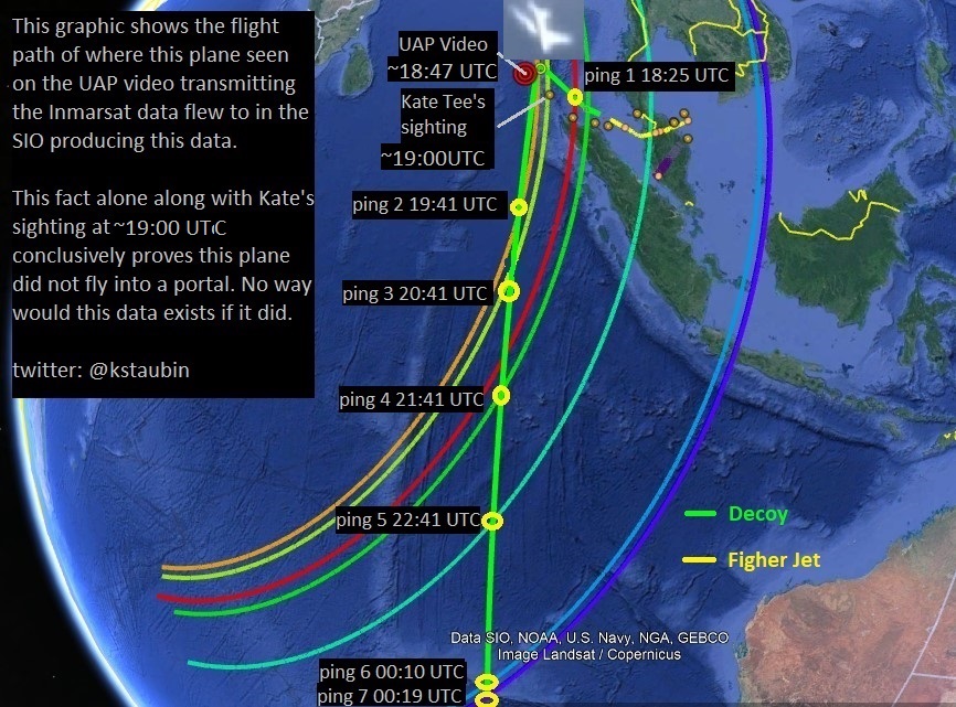
Meanwhile the decoy plane would stay flying at a higher altitude on it's flight path out towards the Straits of Malacca then North West towards Banda Aceh and then turning south heading towards the Southern Indian Ocean (see Figure 4 ). It was the decoy plane and fighter jet that was only seen on radar between the way-points IGARI and MEKAR while MH370 was flying at low altitude completely unseen by any radar and undetected by satellite. Once the decoy plane was off radar, near way-point MEKAR, it then switched on it's AES unit at 18:25UTC which had been reprogrammed, prior to flight, to emit the same AES octal address ID as MH370's AES unit. This was done to make us believe MH370 was still in the air flying and would leave a trail of bread crumbs to mislead us. By doing this all the Inmarsat data after 18:25UTC was generated by the decoy aircraft thus creating the perfect deception and making us think MH370 crashed in the Southern Indian Ocean.
Here is where the decoy aircraft was ditched where 3 sets of data (Inmarsat, imagery, acoustic) converge and seem to indicate some plane, like a B777-200ER crashed down here and this plane cannot possibly be MH370 because debris from this latitude would drift eastwards towards southern Australia and not Africa. Notice how it's flight path trajectory (green flight path) fits in with the Inmarsat data and imagery data as shown by Dr. Bobby Ulich in his contrail flight path theory,

The Decoy (The Clone Drone)
In order for this mission to be successful the CIA needed a second identical aircraft to be used as decoy in case the Malaysians sent up fighter jets to search for MH370. Once MH370 descended to lower altitude it would only be this aircraft (the decoy) that would be seen on radar and this would divert their fighter jets to chase this plane instead of MH370. The CIA even staged a makeshift fire on-board this aircraft to make it look more like the commercial airliner was in distress and it would have not been seen as a hostile aircraft and not likely to have been shot down by fighter jets. |
| Identical aircraft 9M-MRI of MH370 being stored in hanger in Tel Aviv |
This plane was retrofitted with a Boeing Uninterruptible Auto Pilot (BUAP) and was flown like a drone via satellite control by the CIA. It's airborne earth station (AES) was reprogrammed so it would emit the same AES octal address ID as MH370 this way the satellite company Inmarsat would not be able to tell the difference between the two airplanes satellite signals and all data packets received by Inmarsat's ground earth station (GES) would have MH370's unique identifier code in them. Thus the plane being tracked by satellite after 18:25UTC was the decoy aircraft and not MH370.
How exactly was MH370 hijacked by the CIA is unknown however this maybe one possible scenario.
(22:40
UTC) Several hours later, once the plane had landed at Male Airport
(~3:40 AM Local) it was refueled and the passengers, luggage, black
boxes, and unwanted cargo were all removed from the plane . They all
were then put on a boat and taken to Diego Garcia Airbase where they
were processed. What happen to the passengers after this I simply do not
know.
MH370 left Male Airport in early morning hours, before sunrise, and
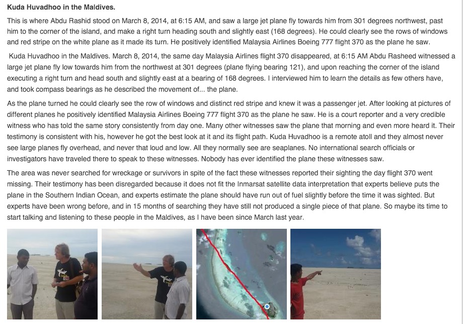
headed south to Thimarafushi Airport (TMF) , where it was spotted near
Kuda Hudvadhoo at ~ 1:15 UTC (6:15 AM Local) , and later near
Gaddhiffushi(before 7:00AM Local), to off-load stolen military cargo
onto another plane and ditch MH370.
MH370 was then flown by a US Navy Ace pilot, who did the short runway take off at TMF , he then set the plane on autopilot on a course heading towards the Andaman Islands and then he did a HALO ( High Altitude Low Orbit) parachute jump before the plane ran out of fuel and crashed into the Andaman Sea. They wanted to ditch the plane not far from last radar contact so it would just look like a tragic accident. The plane crashed into the Sea, with no one on-board, in a spiral dive while the pilot's buddies came and picked him up by boat. Mission accomplished!
MH370 was then flown by a US Navy Ace pilot, who did the short runway take off at TMF , he then set the plane on autopilot on a course heading towards the Andaman Islands and then he did a HALO ( High Altitude Low Orbit) parachute jump before the plane ran out of fuel and crashed into the Andaman Sea. They wanted to ditch the plane not far from last radar contact so it would just look like a tragic accident. The plane crashed into the Sea, with no one on-board, in a spiral dive while the pilot's buddies came and picked him up by boat. Mission accomplished!
The Witnesses
(17:20-17:30 UTC) . 8 ear witnesses in the district of Merang in Terrenganu heard a loud noise around this time that sounded like an explosion and the sound of the "fan of a jet engine" but they did not see the plane. They heard the noise coming from the north east of their postion.http://www.freemalaysiatoday.com/category/nation/2014/03/12/villagers-heard-explosion-fishermen-net-life-raft/
(17:30 UTC) Here is a report by two fisherman near the Malaysia/Thailand border who saw this low flying plane while out fishing in the South China Sea.
http://www.thestar.com.my/news/nation/2014/03/12/cops-get-reports-on-lowflying-aircraft-and-loud-noise/
http://www.cnn.com/2014/03/19/world/asia/malaysia-airlines-plane-ground-...
https://www.sott.net/article/275440-Did-they-see-the-missing-plane-Eyewitnesses-in-northern-Malaysia-witnessed-a-descending-low-flying-plane

( 18:00 UTC) A farmer, Konok Ibrahim in Tumpat, in Malaysia, said he saw a low flying jet on with it's tail fin on fire at around 2:00 am, The farmer stated that he even saw the Malaysian Airlines logo on this plane. Here is an English translation of their eye witness accounts.
https://translate.google.com/translate?sl=auto&tl=en&js=y&prev=_t&hl=en&...
Here are some other English reports on these sightings :
http://www.thestar.com.my/News/Nation/2014/03/11/Kelantan-duo-report-see...
http://www.sott.net/article/275440-Did-they-see-the-missing-plane-Eyewit...

"It’s the only plane I’ve ever seen flying between Mount Raya and the house."
http://www.twitlonger.com/show/n_1skugrg
(19:20 UTC - 19:42 UTC) Eye witness Katherine Tee, on her boat, said she saw a low flying aircraft off the coast of Sumatra, glowing orange with a trail of smoke following it at between 19:20 UTC and 19:42 UTC early that morning. Here are some reports on her sighting
http://www.thehuntformh370.info/content/right-place-right-time-observati...
http://www.independent.co.uk/news/world/asia/mh370-search-british-sailor...
Read this report by Blaine Alan Gibson: http://www.thehuntformh370.info/content/plane-sightings-sightings-kate-tee

http://www.theaustralian.com.au/business/aviation/the-maldive-islanders-...
http://www.dailymail.co.uk/news/article-3025270/I-make-plane-s-doors-Inh...
Read this report by Blaine Alan Gibson: http://www.thehuntformh370.info/content/blaines-independent-investigation
Read this report from Sergio Cavaiuolo: http://www.foundmh370.com/MH370-MaldivesObjectLocationVisit.pdf


 |
| Gaadhiffushi is located just to the North East of Thimarafushi airport. |
(06:30 UTC) Here is another eye witness report from a woman, Mrs. Raja Latife Dalelah, on
an airplane flying to Kuala Lumpur. She said she saw this "airplane
like object" floating in the water at around 2:30PM (6:30 UTC) March 8th
near the Andaman and Nicobar Islands. I believe it was here where
MH370 was ditched, eventually breaking apart in pieces drifting south,
and it's debris was later captured by satellite off the coast of Sumatra
on March 16th?

How can all these witnesses have seen this mysterious plane, on the same day, at different locations, several of which said it seemed to be on fire, and there not be some truth to story they are telling? All the witnesses swore they saw an airplane that day and the witnesses in the Maldives are convinced it looked exactly like MH370. How many times before or after March 8th, 2014 has a low flying jetliner, that looked like a B777, has been seen flying over the Malaysian peninsula or the Maldives? The answer is never, which is why these eye witness reports must be taken seriously . Shouldn't the authorities not be more curious about this and investigate these claims.
The Inmarsat Problem
At 18:25 UTC, just after last radar contact at 18:22 UTC, the airborne earth station (AES) unit on the decoy airplane (N105GT) was switched on emitting handshakes to the 3F1 satellite on an hourly basis this would make it seem that MH370 flew for several more hours and eventually crashed somewhere else at a later time. It would also buy the CIA time while they were off loading the cargo from MH370 at Thimarafushi Airport to then fly the plane back to where they ditched it near the Andaman Islands.The AES unit on the decoy plane was reprogrammed prior to flight to emit the same unique identifier code as MH370's AES unit and the aircraft was modified not to transmit any ACARS data that would give away it's true position. By doing this it would lead the British company Inmarsat to believe that MH370 was still in the air flying for several more hours but would not be able to tell where it's actual position was.
 |
| Figure 6: Inmarsat BTO data from 18:25:27 UTC - 00:19:37 UTC |
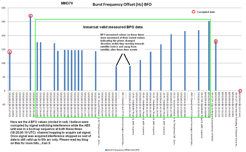 |
| Figure 7: Inmarsat BFO data from 18:25:27 UTC - 00:19:37 UTC |
One thing the CIA could not have for seen in the planning of their operation was that Inmarsat was recording the Burst Timing Offsets (BTO) and Burst Frequency Offsets (BFO) on these satellite pings (handshakes) from the decoy plane's AES unit. This presented them with a very huge problem because if that data became public it would indicate that the decoy plane flew for several more hours and that it could have crashed along an arc indicating it's true position of where the CIA had made the decoy plane (N105GT) crash. The CIA did not want this data to be public because they did not want us to know of the existence of this plane nor did they want us to know where it's crash location was in the SIO. If the search teams ever found the decoy plane (N105GT) they would automatically assume it was MH370 however if they checked the serial numbers of the parts they would eventually find out that this plane was not MH370 and this would blow their cover-up plan so the CIA would do anything possible to keep this secret buried at the bottom of the Indian Ocean.
When the CIA got wind of this information from Inmarsat I believe they went into damage control mode to try to prevent this information from becoming public and decided to kill the satellite controller who was working on the Inmarsat data in hopes this would somehow make this problem go away. Remember the story of the Inmarsat satellite controller, who died a week later after the disappearance of MH370, suddenly from a heart attack? Unfortunately for them this plan did not work and the Inmarsat data was eventually released.
Here is a blog entitled the " The Untimely Death of Mr.Stuart James Fairbairn". Did he unintentionally come across something he was not supposed to see, e.g. the falsification of BTO/BFO values from MH370?
When the search area eventually moved down to the SIO off of
Perth, in an area where debris from the decoy plane (N105GT) was
spotted by satellite near it's crash site, the CIA devised plans on how
to distract the searchers and make them move away from the real crash
site. One of their plans that worked was to have someone tell the ship
Ocean Shield to go look in a certain area where the CIA had dropped
pingers in the water to make us believe that the black boxes and
wreckage were in this area much further North away from the debris
field. This would give the US military some time to clean up the debris
field while everyone else was focused on the other search area. This
plan worked brilliantly.Covering up the evidence
The CIA realized that if the search authorities ever found any pieces of N105GT they would automatically assume it was from MH370, since this was the only plane that had vanished in March 2014. However they also realized that if the authorities were to ever check the maintenance tags on these debris pieces from N105GT with the maintenance records they would eventually discover that these pieces were not from MH370. So in order to maintain the perfect cover-up, and negate this problem, the CIA decided to torch the avionics shop where all Malaysian Airline maintenance records were kept. Perhaps this is why the French authorities are having a difficult time identifying the Flaperon piece (found on Reunion island) with 100% certainty because the maintenance records have been destroyed?Here's a report on this fire: http://www.thestar.com.my/News/Nation/2014/03/28/Fire-breaks-out-at-MAS-...

The Evidence
During the course of my research into debris images spotted on Tomnod (DigitalGlobe's search campaign for MH370) I concluded that there were two possible locations in the Indian Ocean where a 777 airplane may have crashed. One off the coast of Sumatra and the other one in the Southern Indian Ocean near the 7th arc. Originally I thought that the plane debris off of Sumatra was MH370 but after researching this more and reviewing all the inconclusive data (Inmarsat, radar, acoustic, and imagery) and reading the theories by other experts, such as Dr Bobby Ulich, I then concluded, at that time, that MH370 did indeed crash into the Southern Indian Ocean (SIO) most likely near Dr. Ulich's endpoint along the 7th arc. |
| Debris captured by satellite in Southern Indian Ocean (SIO), March 25th and 26th, 2014 |
The question that has been haunting me for several months was " If MH370 did crash in the SIO then why does there appear to be another airplane that has crashed off the coast of Sumatra that looks like a B777?". Why is there also so many eye witness reports of a low flying plane that looked like a B777? Many people have tried to discredit these images and tell me they are not plane parts but the majority of people I have spoken with, along with some satellite imagery experts, who have seen these images believe they possibly could be. I have always stuck to my belief that these were indeed aircraft parts because the mathematical probability that these are just random pieces of junk that look this astonishingly similar to plane parts seemed very improbable to me. I have always believed they were but if they are not pieces of MH370 then from which plane did they come from and what is this plane doing in the Indian Ocean at a time where the entire world is looking for a missing plane that looks like this? Is this plane MH370?
 |
| Debris captured by satellite off the coast of Sumatra, March 16th, 2014 |
More interesting is if we are to assume that the sighting off of Sumatra is indeed MH370 then drift analysis, done by the company GEOMAR , suggests from this location it is possible for debris to have reached Reunion Island within this time frame. It is possible that the flaperon and other debris may have circulated in gyros for several months before moving into currents that would eventually take them to Reunion Island and perhaps even the Maldives. THE PLACE WHERE IT LANDED!

 |
| Figure 8: Composite reverse drift model for all debris pieces found thus far in Africa |

SIO Forward Drift Model: Click on image to animate.

Now that we have found
evidence that two airplanes may have crashed into the Indian Ocean in
March of 2014 one off the coast of Sumatra and one in the Southern
Indian Ocean then we must completely rethink our theories. This could
not have been a simple hijacking, pilot suicide, mechanical problem, or a
fire/decompression emergency, but rather this would had to have been a
conspiracy, something much more sophisticated and sinister than we have
previously imagined.