MH370: The Mysterious Case of the Radar Data.
- Updated Nov. 2nd, 2023
On July 30th 2018 the Malaysian Air Crash Investigation Team looking into the disappearance of MH370 released their latest Factual Information Report which contained new, and important information, about the Military radar data track which authorities believe is MH370. This new radar data contained information on the speed and altitude values of this detected aircraft (blip) which was seen on their military radar shortly after MH370's disappeared from civilian SSR radar.
The Radar Data

 The data shows a detected aircraft (blip) reported flying across the Malaysian peninsula at altitudes ranging between 24450 ft and 47500ft flying towards Penang and then flying at 44,700ft near Penang and several minutes later reaching altitudes of 58200 ft and then descending drastically in altitude to 4800ft near Pulau Perak. The radar data then shows the plane ascended back up to the an altitude of 29500 ft before disappearing from radar.

When investigators studied this data they must have quickly determined that there must be some "inherent error" in this data because the results seem to show that this detected aircraft (blip) was flying at speeds and altitudes well beyond the performance limits of MH370. A B777-200ER has a maximum altitude limit of 44,000 ft and this plane flew above that limit. Since investigators believed that this detected aircraft must be MH370 they quickly concluded that there must be some major "inherent error" in the Military radar data because if these altitude and speed values are correct then their theory is bogus and this detected aircraft (blip) CANNOT POSSIBLY BE MH370.
These baffling facts gave investigators no choice but to add this disclaimer into their report saying that the radar data altitude and speed values were subjected to inherent error and should be disregarded. They had no choice but to include this comment in their report or this radar data would debunk their own official theory.

"It was highlighted to the Team that the altitude and speed extracted from the data are subjected to inherent error."
Who highlighted this to the Team? The RMAF? What proof did they show them of this "inherent error"? What is their quantitative estimates of this error? How are we to know if the data should be discounted if we don't exactly know what this error is?
If there was an "inherent error" in the system then why did they not look at radar returns from other air-crafts of known altitude that night and compare calculated altitude results with recorded ADS-B altitude data to determine exactly what this inherent error was and publish it?
I can't imagine that any countries military radar would be so far out of calibration, more than 50%, it can't tell if an aircraft is flying at 20000 ft or 40000 ft. This just seems totally unreasonable to me.
The AFB Butterworth is an Air Force Station of the RMAF, and headquarters of the Five Power Defence Arrangements Integrated Area Defence System (HQIADS). Hard to believe that such state-of-art air defense system would have such a huge calibration error in their radar system on the night one of their passenger jets disappears. It should be noted this base also has RAAF personnel as well.
If they have not analyzed nor specified in the report what this inherent error is in the system then how do we know it may only be a marginal error (+/- 1000ft) or an astronomical error (+/- 25,000ft) ? We don't, so we cannot dismiss these altitude results until further proof is shown.
The fact that they have not publish what this inherent error is believed to be is very telling IMO.
Lets us not forget the cell phone data.

There is no way, based on these cell phone test results, the First Officer's cell phone could have made a connection to the cell tower in Penang above 20,000ft. So if the FO's cell connection is irrefutable fact then MH370 had to be flying below 20,000 ft and more likely below 8000 ft to have made a connection. The factual radar data would have to be in error by greater than 50% error margin for that plane on radar to still be MH370. If the factual radar is correct then no way could this plane, flying at 44,700 ft could have been the source of that cell signal
Don't blame the data
Until investigators can explain in more detail, with mathematical proof, exactly what this "inherent error" is in the radar data that night we should not be so quick to dismiss this data.
Since the RMAF never sent up fighter jets to positively identify this "blip" on their radar screens it is just an ASSUMPTION to believe this plane was MH370.
Because of this inherent error in the data it is now vitally important that all the radar data of that night, including data from other aircrafts that were flying in their airspace, should be released to the public so that independent experts can verify mathematically what this inherent error was that the data was subjected too and calculate altitude estimate taking into account this error.
Until such proof is given I am going to be of the opinion that this radar data is relatively accurate, with a marginal inherent error, and this factual data mathematically proves that the plane detected on radar must be another aircraft, possibly military, also flying without a transponder, and is most likely a fighter jet and the second part was a B777 decoy.

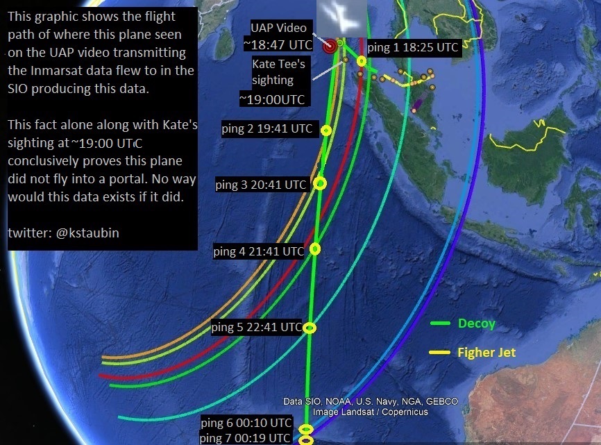
First off, you don't draw a line in your graph between two points where there is no data measured in this time period, that should be left blank. What we are looking at here in my opinion are two planes, one's a fighter jet, and the other one is a B777 aircraft. The fighter jet (yellow track), after crossing the Malaysian peninsula and creating a diversion, descends in altitude dropping rapidly off radar and lands somewhere, perhaps on an aircraft carrier that may have also been jamming radar in that area.

Meanwhile a few minutes later a B777 decoy drone (green track) ascends in altitude appearing on radar along the same flightpath and makes it appear on primary radar to be the same plane. This explains the gap in the radar coverage, they were switching decoys, as well as the difference in the aircrafts speed& altitude performance before and after this gap. The reason there is this difference in speed and altitude performance is because we are looking at two different aircrafts here and neither one is MH370. This is how you make a modern jet airliner vanish, you use decoys to create false data to mislead authorities.
This altitude/speed data for me is the "smoking gun". Prove to me that this data is wrong or we must consider this possibility as being more likely the truth which is why the data is correct.

Do you now see the deception? To me it's bloody obvious that we are being played with here by some very sophisticated military hijackers. Do you now realize that the entire official ATSB theory was based on bogus data created from decoys? This whole fantasy that the pilot hijacked this plane so he could go kill himself in the SIO, is just that, a fantasy! Any theories based on this so called "hard evidence" the RMAF primary radar data and Inmarsat data being valid and from MH370 are also fantasy! This is why the SIO search for this plane has been a hopeless waste of time and nothing was found down there because MH370 never flew down there but a decoy did.
Ken S
Twitter @kstaubin
References
SAFETY INVESTIGATION REPORT
On July 30th 2018 the Malaysian Air Crash Investigation Team looking into the disappearance of MH370 released their latest Factual Information Report which contained new, and important information, about the Military radar data track which authorities believe is MH370. This new radar data contained information on the speed and altitude values of this detected aircraft (blip) which was seen on their military radar shortly after MH370's disappeared from civilian SSR radar.
The Radar Data


These baffling facts gave investigators no choice but to add this disclaimer into their report saying that the radar data altitude and speed values were subjected to inherent error and should be disregarded. They had no choice but to include this comment in their report or this radar data would debunk their own official theory.

"It was highlighted to the Team that the altitude and speed extracted from the data are subjected to inherent error."
Who highlighted this to the Team? The RMAF? What proof did they show them of this "inherent error"? What is their quantitative estimates of this error? How are we to know if the data should be discounted if we don't exactly know what this error is?
If there was an "inherent error" in the system then why did they not look at radar returns from other air-crafts of known altitude that night and compare calculated altitude results with recorded ADS-B altitude data to determine exactly what this inherent error was and publish it?
I can't imagine that any countries military radar would be so far out of calibration, more than 50%, it can't tell if an aircraft is flying at 20000 ft or 40000 ft. This just seems totally unreasonable to me.
The AFB Butterworth is an Air Force Station of the RMAF, and headquarters of the Five Power Defence Arrangements Integrated Area Defence System (HQIADS). Hard to believe that such state-of-art air defense system would have such a huge calibration error in their radar system on the night one of their passenger jets disappears. It should be noted this base also has RAAF personnel as well.
If they have not analyzed nor specified in the report what this inherent error is in the system then how do we know it may only be a marginal error (+/- 1000ft) or an astronomical error (+/- 25,000ft) ? We don't, so we cannot dismiss these altitude results until further proof is shown.
The fact that they have not publish what this inherent error is believed to be is very telling IMO.
Lets us not forget the cell phone data.

There is no way, based on these cell phone test results, the First Officer's cell phone could have made a connection to the cell tower in Penang above 20,000ft. So if the FO's cell connection is irrefutable fact then MH370 had to be flying below 20,000 ft and more likely below 8000 ft to have made a connection. The factual radar data would have to be in error by greater than 50% error margin for that plane on radar to still be MH370. If the factual radar is correct then no way could this plane, flying at 44,700 ft could have been the source of that cell signal
Don't blame the data
Until investigators can explain in more detail, with mathematical proof, exactly what this "inherent error" is in the radar data that night we should not be so quick to dismiss this data.
Since the RMAF never sent up fighter jets to positively identify this "blip" on their radar screens it is just an ASSUMPTION to believe this plane was MH370.
Because of this inherent error in the data it is now vitally important that all the radar data of that night, including data from other aircrafts that were flying in their airspace, should be released to the public so that independent experts can verify mathematically what this inherent error was that the data was subjected too and calculate altitude estimate taking into account this error.
Until such proof is given I am going to be of the opinion that this radar data is relatively accurate, with a marginal inherent error, and this factual data mathematically proves that the plane detected on radar must be another aircraft, possibly military, also flying without a transponder, and is most likely a fighter jet and the second part was a B777 decoy.

First off, you don't draw a line in your graph between two points where there is no data measured in this time period, that should be left blank. What we are looking at here in my opinion are two planes, one's a fighter jet, and the other one is a B777 aircraft. The fighter jet (yellow track), after crossing the Malaysian peninsula and creating a diversion, descends in altitude dropping rapidly off radar and lands somewhere, perhaps on an aircraft carrier that may have also been jamming radar in that area.

Meanwhile a few minutes later a B777 decoy drone (green track) ascends in altitude appearing on radar along the same flightpath and makes it appear on primary radar to be the same plane. This explains the gap in the radar coverage, they were switching decoys, as well as the difference in the aircrafts speed& altitude performance before and after this gap. The reason there is this difference in speed and altitude performance is because we are looking at two different aircrafts here and neither one is MH370. This is how you make a modern jet airliner vanish, you use decoys to create false data to mislead authorities.
This altitude/speed data for me is the "smoking gun". Prove to me that this data is wrong or we must consider this possibility as being more likely the truth which is why the data is correct.

Ken S
Twitter @kstaubin
References
SAFETY INVESTIGATION REPORT


Your blog is really very nice informative and thorough. I read the blogs each time they are sent. Oxygen concentrator machine
ReplyDelete