MH370 UAP Video Analysis, the Proof is in the Clouds.
Updated Dec. 7th, 2023
It is believed that the plane in these UAP videos may be related to the disappearance of MH370 and if that is the case then the timestamp on the video, which is not shown in the video, should be around the time this plane MH370 is believed to have turned south in the Andaman Sea flying into the SIO on the evening it disappeared. Also the GPS position of the plane which is indicated in the video to be around this location (8.828815, 93.195896) should correspond, to some degree, with the predicted flight path indicated by the Inmarsat data.
The correct timestamp for when this plane that was turning south in the Andaman Sea that was transmitting this Inmarsat data, believed to be MH370, is ~07/03/2014 18:40 UTC or 08/03/2014 02:40 MYT. That is the approx. time according to the Inmarsat BFO data for MH370 of where this plane was changing direction and moving away from the Inmarsat satellite. Before this time the BFO values were decreasing as the plane was flying towards the Inmarsat satellite then they level off around this time and then the BFO values start to increase as the plane moves away from the Inmarsat satellite, this is due to a Doppler Effect. So it's clear from this BFO data that the plane was turning, changing direction, at around this time.
 |
| MH370 Inmarsat BFO data |
%20v2.jpg) |
| MH370 Flight Route (DECOY) |
It's possible that the actual turn time was closer to 18:47 UTC because of the distance between video coordinates and last point of radar contact (220 nmi), as well as the max. speed performance of a B777-200ER. If we use the last recorded airspeed (516 kts) on PSR radar as a reference then it would have turned at the video coordinates at ~18:47 UTC assuming it flew on a straight path as shown in graphic.

What we know from the video is the satellite's name (NROL-22) and the coordinates (8.828815, 93.195896) of where the video was taken but what we don't know exactly is when this video was taken. What has been determined from my research is that NROL-22 was indeed in a location to have been able to have relay the video signal at that time 07/03/2014 18:40 UTC.
 |
| The last four digits in the coordinates vary slightly in the video |
We also know from the uploaders YouTube account (RegicideAnon) that the original video file was uploaded to YouTube on the 12 March 2014, four days after MH370's disappearance, but was only published on the 19 May 2014. This would have given this uploader approx. 60 days to edit the video if he wanted to. The FLIR Video was published by him on June 12th, 2014.
UPDATE: It has now been noted that the original publisher of the satellite video may have been the YouTuber DUAL GAMMA on March 10th but his version was deleted and never archived so we can't be certain if it is the same video or the same version. This version circulating on the net is the May 19th version published by RegicideAnon on YouTube.
Satellite tracking data (07/03/2014 18:40 UTC)
Here is the tracking data for the satellite USA-184 (NROL-22) (red track) at the time it is believe MH370 would have been turning south in the Andaman Sea 07/03/2014 sometime between 18:30 UTC - 18:50 UTC. It seems that this satellite was at the correct ~ latitude but 1000s of Kms away over Africa and was nowhere near the video coordinates. The satellite location at this time was over Africa.


So my conclusion here is that this satellite USA-184 (NROL-22) (red track) could not have been the satellite to have taken the UAP video but most likely was the relay satellite that was re-transmitting the signal back to the U.S. and to whoever was recording it. If you are going to stream a live video (without internet) from the other side of the globe you would have to have a relay satellite at a high enough altitude to do this.

If indeed this video is related to the disappearance of MH370 then the coordinates are not that of the sat USA-184 (NROL-22) but rather most likely show the coordinates of where the camera was pointing (center of screen) at a point on earth and where the plane was turning (8.828815, 93.195896) at 18:40 UTC.
The question now is which satellite did take the video? USA-229 (NROL-34) (blue track) which was in a low earth orbit (LEO) is one possible candidate that was in the area at that time but at this point I am certain it was not because it's perspective (east of video coordinates) does not seem to align with the perspective in the video as we understand it and it was moving too fast (890 Km/min) to have taken such stationary video,
USA-230 SBIRS GEO-1 (orange track) was in geostationary orbit (GEO) directly above the predicted flightpath. USA-230 has IR capabilities (SBIRS) and is capable of detecting missile launches, nuclear explosion. as well as aircrafts. It's hard to believe this satellite did not see that plane giving it's location at the time directly over the predicted flightpath. They must have at least detected this aircraft. This satellite could not be the satellite that took the UAP video because of it's locations at this time but certainly were in a position to detect this aircraft flying into the SIO.
USA-223 (NROL-32) (green track) This satellite could not be the satellite that took the UAP video because of it's locations at this time but certainly were in a position to detect this aircraft flying into the SIO.
USA-171 (NROL-19) (yellow track) which was in a geostationary orbit (GEO) west of the Maldives which would have had the correct perspective as the video . Public information on this Orion class satellite is very limited and is classified. What is known publicly about this satellite is that it was developed by the CIA and its mission, of course, is classified.

USA-202 (NROL-26) (pink track) which was in a geostationary orbit (GEO) west of the Maldives which would have had the correct perspective as the video . Public information on this Orion class satellite is very limited and is classified. What is known publicly about this satellite is that it was developed by the CIA and its mission, of course, is classified.

USA-241 SBIRS GEO-2 (white track) which has SBIRS capabilities was located to the west of the video coordinates over Africa at this time.This is the only SBIRS satellites that could have taken the UAP video from the west bit unfortunately this is not a pair satellite so it could not of have taken a stereoscopic IR video.
We can see from this frame in the video and the 3D CAD model that in order to view a B777 from this perspective the satellite's viewing angle would have to be ~10 deg above the plane's horizontal axis or bank angle.If we assume the planes bank angle was nominal <30 deg then this information tells us that the satellite that took this video was at an elevation angle no more 40-45 deg max.


So I have concluded, based on the research that I've done that the satellite that most likely took this UAP satellite video was most likely a pair of highly classified Orion Class satellites USA-202 (NROL-26) A/B operated by the NRO/CIA. The exact optical capabilities of these satellites are unknown but are pair satellites that were in the right location in GEO orbit at the right elevation angle to take that stereoscopic stationary IR UAP video from the west.
My personal feeling on these videos is that it is indeed real footage taken from a drone and a satellite, the plane and the UAP's are real, but the portal explosion is an added visual effect to create the illusion aliens hijacked MH370 and not the CIA the guys who were controlling the plane and taking these nice incredible videos of it. I believe this video is a hoax put out by the CIA using their own real satellite/drone footage to try to fool us into believing aliens made MH370 vanish and not them. I believe the plane in this video is related to MH370 and they may have just shot themselves in the foot by leaking this video of this plane to the public.
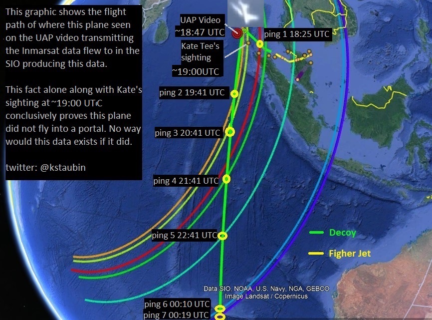
If this plane did teleport into a portal in the Andaman Sea the last 6 Inmarsat pings would not exist and neither would all the confirmed/unconfirmed debris in Africa either. So in that sense this part of the video has to be a hoax but everything else in this video is real in my opinion including the orbs,
Here is a similar video taken in 2013 in Madrid which shows another plane being surrounded by these orbs.


This looks like a poor copy/paste job indicating to me this part of the video was edited with this VFX effect added to the raw footage. It is less unbelievable to me that this whole video is a masterful 3D rendering of this entire scene done by this artist. More likely the raw unedited video footage is real and he's just an average VFX artist.

I am certain this portal is just VFX effect stock footage that was also used in this TV episode of 'Eastbound and Down'. We know that the portal in this video must be fake so why would it not be fake in the UAP videos as well? Watch the video here.
To me, if this video can be proven to show that this plane in the video is the plane that transmitted the Inmarsat data from MH370 then this is just further proof that the CIA are most likely the ones who hijacked MH370 and they're pretty good at adding visual effects into their own videos. The existence of the physical debris evidence as well as the Inmarsat data, witness data, imaginary data, radar data tells me MH370 did not teleport into another dimension, it's somewhere in the ocean where the CIA ditched it.

What illuminates clouds at 12:40 am in the morning? It has to be moonlight or star light that is illuminating the clouds at that time not sunlight. The false color IR is what makes it appear as sunlight in the video.
I agree with those who say the light source illuminating the clouds was coming from behind or above the camera. However I believe this may have been some moonlight coming from the west (behind satellite) or simply starlight from above which in false color IR appears brighter like sunlight. It would've been 12:40 am in the Andaman Sea at that time, nowhere near sunrise.
Notice the clouds in video remain relatively stationary in the same place (not moving very much) in relation to satellite's camera which indicates to me this video was taken by a geostationary satellite at high altitude from the west.
Comparison of cloud formations from March 07, 2014 in our area of interest.
This analysis and comparison of the cloud formations on March 7th, 2014 ~18:54 UTC between this NASA satellite image and both UAP videos have at least 18 points of similarities that indicate indeed these UAP satellite/FLIR videos were taken on March 7th, 2014 at around this time at this location. You can't easily fake that.
 |
| MH370 UAP FLIR Video Cloud Comparison |
 |
| Cloud Comparison |
I'm now convinced these videos are real and are indeed videos of this Inmarsat plane (believed to be MH370) turning south into the Southern Indian Ocean (SIO) and were taken by a U.S. drone and satellite on this day (March 7th, 2014), at this time (~18:47 UTC), at this location (8.828815, 93.195896).
Such a revelation proves that the people who were taking these images (CIA/U.S. DoD) must know allot more about what happened to MH370 if they were taken videos of this plane while it was flying into SIO. I bet they were surprised and shocked when they found out they were not the only ones who were observing and monitoring this plane.

 |
| MH370 Satellite Video Camera Angle |
 |
| EOSDIS NASA Worldview satellite image of cloud formations in our area of interest on March 7th, 2014. |
 |
| Orbital track for SUOMI-NPP satellite at 07/03/2014 18:54 UTC |


My candidate drone that took the FLIR video is the MQ-1C Gray Eagle Predator UAV which has 3 FLIR pods (IR cameras) installed on it with two under the wings that gives it a unique camera perspective (from the wing) and stereoscopic pseudo-color IR video as well as thermal vision like we see in video. It also has a maximum altitude of 29,000 ft.
 |
| MQ-1C Gray Eagle Predator UAV |
What I am trying to do with this post is not to debate, or disapprove, whether the UAP's or portal in this video are fake, or not, what I am trying to show here is the possibility that the raw footage is real and the plane in this UAP satellite video and FLIR video is the plane that transmitted the Inmarsat data on the night MH370 disappeared. The raw footage of this video may indeed be actual leaked footage (recorded screen capture on a computer screen) by a U.S. Intel source and actually shows footage downlinked from a U.S. Spy satellite (NROL-22) from a drone that was leaked by this source to the public shortly after MH370's disappearance.
These are my conclusions thus far,
1- Based on comparison of the cloud patterns between the NASA satellite imagery taken on March 7th, 2014 at around ~18:54 UTC at the coordinates indicated in UAP video and the cloud patterns in both videos I have found at least 18 points of similarity indicating to me that the videos are real and were taken at that location, around that time, on that day.
2- The BFO data is correct the plane turned at ~18:47 UTC
3- The video gives us the coordinates of around where the plane was at this time, not the satellite.
4- The satellite tracking data tells us where USA-184 (NROL-22) was at that time and it could not have been the satellite that took the UAP video but rather most likely was being used as the relay satellite and the video was recorded off this satellites' downlink.
5- The satellite that most likely took this UAP satellite video was most likely a pair of highly classified Orion Class satellites USA-202 (NROL-26) A/B operated by the NRO on behalf of the CIA. The exact optical capabilities of these satellites are unknown but are pair satellites that were in the right location in GEO orbit at the right elevation angle to take that stereoscopic stationary IR UAP video from the west.
6- Orbs are real, plane is real, footage is real, clouds are real, but not the portal that has to be an added VFX because of the Inmarsat data and physical evidence we have that says MH370 is somewhere in the ocean and is not in another dimension.
7- The plane transmitting this Inmarsat data did indeed turn south into the SIO and the experts really do understand this data correctly. Only question is, was this plane actually MH370 transmitting that data? TBD.
8- The drone that took the UAP FLIR video was a MQ-1C Gray Eagle Predator UAV which has 3 FLIR pods (IR cameras) installed on it with two under the wings that gives it a unique camera perspective (from the wing) and stereoscopic pseudo-color IR video as well as thermal vision like we see in video. It also has a maximum service ceiling altitude of 29,000 ft.
9- The CIA /U.S. DoD knows everything. They're the, "someones who know something"!
Given the location of where this video was taken in the Andaman Sea, where there are no known air routes and the timing of its existence, 4 days after MH370's disappearance, and it's visual match to a B777-200ER airliner, it is very likely we are seeing in this video the plane that was transmitting this Inmarsat data that evening than any other plane. If this is this plane that was transmitting this Inmarsat data that evening MH370 disappeared then this video proves the CIA/U.S. DoD must know a hell of allot more about what happened to MH370 and for some strange reason they haven't informed the public about this.
WHY?????
Here's a link to my theory.
MH370 : The Unspeakable Truth.
About the Author:
Here is also a link to my twitter (X) account @kstaubin which I put up allot of my research on #MH370 on my timeline.
Satellite Information:
.jpg) |
| USA-184 (NROL-22) |
%202.jpg)

USA-241 SBIRS GEO-2


References
Reference 1: NROL-22 Satellite Analysis in Relation to MH370.
Reference 2: Here are NROL-22 (USA-184) flight data from March 8th, 2014:
Reference 3:The Ultimate Analysis: Airliner videos and the Mh370 flight.
Reference 4: JSatTrak: Software for visualizing satellite TLE files
Reference 5: Fact Sheet on Space Based Infrared System
Reference 6: USA-184 (NROL-22) TLE data from 2006 - 2022.txt
Reference 7: List of NRO launches
Reference 8: USA-230 SBIRS GEO-1
Reference 9: USA-171 (NROL-19)
Reference 10: USA-223 (NROL-32)
Reference 11: USA-229 (NROL-34)
Reference 12: USA-184 (NROL-22) SBIRS
Reference 13: USA-200 (NROL-28) SBIRS
Reference 14: USA-241 SBIRS GEO-2
Reference 15: Exploring the Pros and Cons of Geosynchronous Spy Satellites
Reference 16: Satellite positions during the "event" for u/Kens2023
Reference 17: MH370 NRO Historical TLE data for March 8th, 2014 .txt file
Reference 18: MQ-1C Gray Eagle Predator
Reference 19: SBIRS Datasheet
Reference: 20: A radio telescope in the sky: the USA-202 ORION satellite


Thanks for the info
ReplyDeleteThis comment has been removed by the author.
ReplyDeleteThis comment has been removed by the author.
ReplyDeleteThis comment has been removed by the author.
ReplyDeleteThis comment has been removed by the author.
ReplyDeleteWas "DUAL GAMMA" the original leaker of this UAP sat IR video on March 10th, 48 hrs after event? Is he the original leaker who may have passed this video to RegicideAnon? We'll never know b/c his version of video was never archived.
ReplyDeleteI believe the original reason this video was recorded is because of the orbs. The orbs are real and because of this the original leaker who recorded this screen capture video must have been so astonished by their presence of these orbs in this video he had to make a screen capture of that part of the video. I believe this original unedited version would show the orbs , just before portal, zipping off to right of the plane as it continues flying south which is why the camera continues to pan right after VFX portal.
I believe he then leaked this video to RegicideAnon via Youtube and it was him (or them) who published the video two months later and added the fake portal in this video to stigmatize the video, making it seem aliens made this plane vanish, and give it plausible deniability as a hoax should people take it seriously yet leave enough info in the video to make us believe this plane is MH370.
The CIA are brilliant at psyops. They're showing us what happened to MH370 but none of the experts believe this b/c of the VFX portal and think the whole video is CGI. They have of others believing in crazy conspiracies' the aliens did this and made the plane vanish or the U.S, has some sort of easily deniable Star Trek teleportation weapon Brilliant!