MH370: The Unspeakable Truth.
Updated December 29th, 2023
By Ken St. Aubin
Introduction
On March 8th, 2014 the passenger aircraft MH370, flying to Beijing from Kuala Lumpur, and it's 239 passengers and crew simply vanished into the night without a trace and 9 years later the public and grieving family members still don't know exactly what happened to that plane or their relatives. The only solid physical evidence that has been found of this plane is about 30 plus pieces of it's debris that has washed ashore on the shores of eastern Africa. What happened to this plane has become aviation's greatest mystery.

After a several year hiatus from doing research on MH370 and blogging about it I decided I would revisit and review my 5 years of research that I did on MH370 from day one (March 8th, 2014) when the plane disappeared to about 2019 and try to explain again my reasoning and evidence/data in a more clearer and less speculative way as to why I believe this plane was deliberately hijacked by state actors.
I felt compelled to do this because I sincerely believe that my research and theory may help to explain the mystery of this plane and where we may find it's wreckage. I felt it necessary that this information be documented properly in case any future ocean explorers may want to investigate my claims and try to find this wreckage where I believe MH370 was ditched.
ATSB Official Theory
On March 8th, 2014 flight MH370 was flying from Kuala Lumpur, Malaysia to Beijing, China when the plane's transponder was mysteriously shut-off over the South China Sea just after the waypoint IGARI before entering Vietnamese airspace and disappearing from secondary ADS-B radar at around 1:21 am (17:21 UTC) just after Captain Zaharie Ahmad Shaw radioed his final message, "Good Night Malaysia 3-7-0" .
According to the official theory, which the Australian Transport Safety Board (ATSB) purports happened, is that after MH370's transponder was turned off just after the waypoint IGARI a few minutes later the plane was picked up on military primary radar only and was tracked flying back over the Malaysian peninsula towards Penang with no transponder signal. It then turned north up the Malacca Straits where it disappeared from their radar (18:22 UTC) and presumably turned south then flew into the Southern Indian Ocean (SIO) for another 5 hours based on the Inmarsat data where it supposedly crashed somewhere along an imaginary 7th arc where it transmitted it's final sat ping at 00:19UTC .
Their theory is based on primary military radar data that was given to them by the Royal Malaysian Air Force (RMAF) and Inmarsat signal data that was given to them by the satellite company Inmarsat.

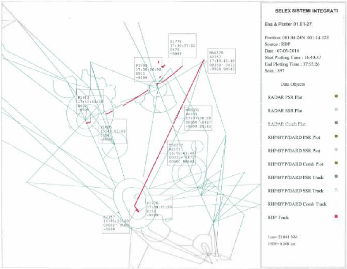

This image shows the "radar blips" from this unidentified aircraft(s) detected in the Straits of Malacca. Why wasn't this radar data plotted on the RMAF radar graphic above? Why is there a gap in the radar here?

Primary Radar Altitude and Speed data
This recorded altitude and speed data was only published in the Malaysian Government's final safety investigation report in 2018, 4 years after the plane disappeared. Why did it take so long for them to publish this data?
This plane being tracked on military primary radar based on this recorded altitude data cannot possibly be a B777-200ER aircraft like MH370 and thus here is where the deception begins.

It's hard for me to imagine that such a state-of-art radar system design to protect a countries airspace would be so far out of calibration that it can't even tell the altitude and speed correctly of airplanes flying in it's airspace. You have to be an extremely incompetent military to have allowed this to occur. I don't buy their explanation that their radar was not properly calibrated that evening and there was this "inherent error" in the data.
Show me the proof the altitude and speed data is wrong otherwise we must assume this data is valid and accurate until proven otherwise. I don't believe that there is any significant "inherent error" in this altitude and speed data. All measured data has some inherent error in it the question is how significant is it? We should not be dismissing this data without any proof that it is irrelevant.
So if we assume the altitude and speed data for this primary radar track is relatively accurate then we must throw the official ATSB theory in the garbage because that plane turning back towards Penang cannot possibly be MH370 based on this valid altitude an speed data.
The Cover-Up
If the RMAF are feeding us this bullshit primary radar data then one has to ask ourselves why are they doing this and where did this plane go after losing transponder signal after the waypoint IGARI? If the RMAF are lying to us to mislead us away from some unspeakable truth then we must seriously pay more attention to those ground witness reports that contradict this radar data and tell us a whole different story of where this plane went that evening after MH370 had shut-off it's transponder signal at waypoint IGARI.
Let me explain the radar deception first and what I believe we are actually seeing with this RMAF primary radar track data. Once you see the deception you'll understand why the SIO search is a hopeless waste of time.
I am convinced that the ground witnesses who saw this low flying plane that evening are telling us the real truth about where MH370 flew that night and the RMAF, who gave us this bogus radar data, are complicit in a cover-up and know very well that this plane was a fighter jet and not MH370.
I am certain that there is no significant "inherent error" in the altitude and speed data that was recorded and published and until proven otherwise we should accept this data as relatively accurate and valid with only a marginal inherent error. This is well within scientific and mathematical principles to do so.

If this is the case then this plane seeing turning back on primary radar was not MH370, because B777s can't fly like that at those altitudes, but rather a fighter jet (yellow track) and the plane flying out to the SIO (green track), last seen on radar at 18:22 UTC, was a B777 drone decoy that transmitted the false and misleading 7 ping Inmarsat data. This is why there is this gap (no data) in the radar coverage, they were switching decoys. MH370 was flying at low altitudes during this time period being undetected by military radar and only being seen by a few ground witnesses at this time (red track).
I believe that the B777 drone may have taking off from Butterworth AFB near Penang (the same jokers who gave us this bogus radar data) where it flew out at low altitudes over the Straits Malacca before ascending and appearing on radar. The fighter jet may have also returned to this military base after dropping off radar.

First off, you don't draw a line in your graph between two points where there is no data measured in this time period, that should be left blank. What we are looking at here in my opinion are two planes, one's a fighter jet, and the other one is a B777 aircraft. The fighter jet (yellow track), after crossing the Malaysian peninsula and creating a diversion, descends in altitude dropping rapidly off radar and lands somewhere, perhaps on an aircraft carrier that may have also been jamming radar in that area.
Meanwhile a few minutes later a B777 decoy drone (green track) ascends in altitude appearing on radar along the same flightpath and makes it appear on primary radar to be the same plane. This explains the gap in the radar coverage, they were switching decoys, as well as the difference in the aircrafts speed& altitude performance before and after this gap. The reason there is this difference in speed and altitude performance is because we are looking at two different aircrafts here and neither one is MH370. This is how you make a modern jet airliner vanish, you use decoys to create false data to mislead authorities.
This altitude/speed data for me is the "smoking gun". Prove to me that this data is wrong or we must consider this possibility as being more likely the truth which is why the data is correct.

MH370 DID NOT END IN THE SOUTHERN INDIAN OCEAN!!!
I am convinced today, more than ever, that this plane (MH370) was deliberately hijacked by a group of very sophisticated state actors who flew this plane to Male Airport in the Maldives to retrieve sensitive secret cargo ,weighing 89Kg that was loaded onto the plane at the last minute and listed on the cargo manifest only after takeoff. They used decoys to create false Inmarsat/radar data and used this data to cover their tracks and throw the civil authorities off their trail. So far they've been successful for 9 years with this scam.
The Cargo
This 89Kg cargo was most probably being smuggled on-board this plane illegally into China and may have contained stolen classified military hardware stolen off a U.S. flagged container ship.
Read this article about this interesting report that was allegedly circulating around the Kremlin prepared by the Russian Main Intelligence Directorate of the General Staff of Armed Forces (GRU) shortly after MH370 went missing. Here is what this report says about the cargo.
Interesting to note, this report says, was that Flight 370 was already under GRU “surveillance” after it received a “highly suspicious” cargo load that had been traced to the Indian Ocean nation Republic of Seychelles, and where it had previously been aboard the US-flagged container ship MV Maersk Alabama.

Did this suspicious cargo on-board MH370 come from the Maersk Alabama and was it linked to deaths of these two ex-Navy Seals? This suspicious incident happened two weeks earlier, in February of 2014, on the U.S. container ship Maersk Alabama in the Republic of Seychelles, Africa?
I believe this suicide story is a cover story for what really happened on-board that ship. There is something about this NY Times story that doesn't seem right to me and their family members don't buy it either. No way did these guys kill themselves with a heroin overdose because of loneliness and boredom. What was on-board that ship and what valuable cargo were they guarding?
I believe these two Ex-Navy Seals were murdered by hookers who injected them with a lethal dose of heroin while pirates stole valuable "booty" that was on-board that ship and they knew exactly which container it was in. I believe these pirates then brought this cargo to Malaysia where they sold it to Chinese smugglers for big cash. These Chinese smugglers then arrange to have this cargo put on-board MH370.
I think these smugglers miscalculated by putting this cargo on-board a passenger jet thinking this was the safest way to smuggle this stolen cargo into China falsely believing that these state actors would not harm the innocent passengers on-board this plane once it was in the air.
If this GRU report is true then this explains allot as to why MH370 was hijacked and where this suspicious cargo came from and why those two ex-Navy Seals on-board the Maersk Alabama may have been murdered. Could the hijacking of MH370 have also been payback and revenge for the death of these ex-Navy Seals as well as retrieval of this sensitive stolen cargo?
I also believe that those 20 Chinese engineers that were on-board MH370 from the company Freescale may have had a connection and prior access to this cargo and who may have also been targeted by these hijackers as well. I believe the hijackers may have also wanted their laptops, cellphones, or zip drives they may have had in their possession in case there was any sensitive data on these devices and also to use them for intel purposes to find out who was behind the hacking and murders.
This also could be the reason why the Chinese Government doesn't really want this plane to be found because the truth would embarrass them. That's why they haven't been so enthusiastic about searching for MH370 because they were the ones trying to smuggle stolen military hardware into China by putting it on-board MH370 and by doing so they got everyone on-board killed including 153 of their own citizens.
They also already probably lost several million dollars on the valuable stolen cargo, they mustn't have been to happy about that, and they know exactly who did this but they can't blame them because we can't find the evidence to even prove there was a crime that was ever committed.
If this truth about MH370 ever came out it would be a huge scandal and an embarrassment for President Xi and his Government and potentially increase tensions between U.S. and China. That's why I believe the Chinese have no interest in finding this plane. They've already lost allot of money on it and don't want to waste anymore. For them the truth is better to stay lying at the bottom of the ocean.
The unspeakable cannot be spoken about.
For 9 years now these powerful entities have succeeded in this cover-up and have misled the experts and the public by fabricating, and feeding us, bogus radar data and satellite signal data (Inmarsat data) that were not even created by the plane that went missing, MH370. They have almost perpetuated the perfect crime. To this day experts still believe MH370 is in the SIO because their so called "hard evidence" (Inmarsat/radar data) tells them it's there. Their "hard evidence" tells me exactly where this decoy flew in the SIO and it's useless data for finding MH370.
How does a modern day jetliner just vanish without a trace?
My answer to that question is, a modern airliner does not just vanish without a trace unless some powerful Government wants them to vanish without a trace.
Based on my 5 years of research into the disappearance of MH370 I am convinced from my research that I can see clear evidence of deception on the part of the Royal Malaysian Air Force (RMAF) and I am convinced that some powerful Government(s) and their militaries are most likely the one's who are responsible for the disappearance of MH370 and making that plane vanish.
These state actors have done a brilliant job all these years of deceiving the public and covering up the fact they mercifully murder 239 innocent people to protect the national security interests of certain prominent country and send a message to the Chinese to stop stealing our secret classified technology and trying to smuggle it on-board a civilian passenger aircraft.
After retrieving this cargo these state actors then ditch the plane in the Andaman Sea west of the Andaman and Nicobar Islands to get rid of the the evidence and make this plane and it's passengers/crew vanish so there would be no witnesses or evidence to be found of their dirty deed.
Fortunately for us, they screwed up, and there are witnesses who did witness their dirty deed.
The Witness Data
"Once you eliminate the impossible, whatever remains, no matter how improbable, must be the truth."...Arthur Conan Doyle.
If you want to know the reality and truth about where MH370 disappeared to that night you only need look at the various eye witness reports from that day and ignore the Inmarsat data and radar data completely. What I believe what these witnesses saw and heard that night was the true reality of where MH370 flew after it disappeared from radar at IGARI and the primary radar data that the RMAF gave us, and the Inmarsat data, are just bogus data created from decoys. These are real people with credible stories.

MH370 Flight Path Map
 |
| MH370 Flight Path Route |
This MH370 flight path map above is based on the following ear & eye witness reports from over 30+ witnesses who reported seeing and hearing a low flying passenger aircraft that day on March 8th, 2014. By mapping out these reports by their geographical locations and then connecting them in chronological order (by time of sighting) we can clearly see where MH370 flew that night, where it most probably landed, and most importantly where it was ditched. I believe MH370 did a controlled ditching in the Andaman Sea west of the Andaman Islands based on these witness reports that I have studied.
With this data I make the following three assumptions.
1 - All the witnesses are telling us the truth and their sightings are real.
2 -They all most probably saw the same low flying plane.
3- They all most probably saw the only plane that went missing that day, MH370.
MH370 Disappears from Radar
(17:21 UTC) At the time 1:21 am that MH370 disappeared from radar villagers on a beach in Terengganu (see 2 in map above) heard a loud noise (explosion) which they said sounded like a jet engine. My belief is that this noise they heard was a sonic boom which I believe was caused by MH370 doing a rapid descent to low altitudes and briefly exceeding the speed of MACH 1 causing a sonic boom.

(17:30 UTC) Two fisherman around 1:30 am on the South China Sea (see 3 in map above) see a large plane fly low over their heads. The fisherman said, "it had lights as big as coconuts".
(17:30-17:45 UTC) A businessman in Kota Bharu between 1:30-1:45am see's a plane descending flying low over the South China Sea. (see 4 in map above). He never saw flights in that are area before flying so low.
(18:00 UTC) A farmer later around 2:00am in Tumpat see's this low flying plane (see 5 in map above) and said he saw the Malaysia Airlines logo on the tail of this plane and it was on fire.

Farmer in Tumpat reports low flying plane

(18:30 UTC) A woman on the island of Langkawi, on the west coast of Malaysia in the Straits of Malacca at around 2:30 am saw a plane fly low between her house and Mount Raya (see 6 in map above). Never had she seen a plane flying this low in that area and she said it was a big plane.
All these eye witnesses came forward and reported their sighting to the police and media at the time but the authorities never investigated their claims. Their sightings alone completely contradict the official radar data. The most logical explanation for these sightings is that they all saw the only aircraft that went missing that day, MH370.
(18:40 UTC) Initially it was reported in the news two days after the plane went missing by RMAF officials that MH370 was spotted on radar flying low near the island of Pulau Perak (see 7 in map above) at around 18:40 UTC. This story was later changed to their current radar story but I tend to think this initial report is accurate because it fits with the witness data. It was also reported in this same article that Singaporean authorities detected a rapid descent. Where's that radar data?

If this radar contact is the actual truth then it confirms the witness sightings and that MH370 was flying at low altitude at this time trying to evade radar detection and contradicts the Inmarsat data of where the plane was at that time. Why hasn't this primary military radar data been publicly released on this supposed radar sighting near the island of Pulau Perak? Why would the Air Force Chief make such a statement at that time if it wasn't true?
(19:10 -19:25 UTC) A woman named Katherine Tee and her husband on a boat sailing north of Sumatra (see 8 in map above) witnessed a low flying passenger jet, glowing orange seemingly on fire, smoking, heading west and two military planes flying in formation above it. She also saw 20 minutes earlier another plane flying at high altitude out to the Indian Ocean which she thought was somewhat of bizarre flightpath to take out there.
Watch video here.


I believe what Kate and her husband saw that night was both MH370 ( the low flying passenger plane smoking glowing orange) which was being escorted and hijacked by two military aircraft's above it as well as the decoy plane flying out to the SIO. MH370 was flying low through a volcanic dust cloud that evening which caused the plane to glow orange and it still had it's tail on fire. There was a volcanic ash advisory that evening for planes flying below 12,000ft in that area of Indonesia. I also believe that plane she saw 20 minutes earlier flying at high altitude was the decoy aircraft that was transmitting the false Inmarsat data and was flying out to the SIO. I believe she and her husband are the only witnesses who saw both the decoy as well as MH370 validating my 2 plane decoy theory.


Male Airport
There is no proof that MH370 landed in the Maldives but in this case the absence of evidence is not proof of fact. The fact that there are no witnesses sightings of this plane landing at Male airport to me does not discount this possibility but rather I see it as a testament to how well these hijackers concealed themselves.
(~22:40 UTC) I believe MH370 landed at Male airport (see 9 in map above) at around ~3:40 am local time under the cover of darkness and it was greeted by these very powerful state actors, who had access and control of this airport. I believe that after MH370 left Indonesian airspace, while flying across the Indian Ocean where there is no radar coverage, it ascended back up to an altitude of FL200 and flew for another 3 hours 15 mins approx. after Kate's sighting until reaching Male airport. This would save time and fuel.
I believe the plane landed there under the cover of darkness at ~3:40am, unseen by radar, and was unloaded and refueled at the far end of the runway away from the terminal building. This would have happened at a time (between 3:00am -6:00am) when there were no arrivals and departures at the airport when it was less busy with travelers. Because the plane was at the far end of the runway the nearest witnesses would have been over a mile away from any direction and would only have seen some plane with lights on, surrounded by trucks, far off in the distance, at night, at the end of the airport runway. There would be nothing out of the ordinary or suspicious about this that would raise anyone's attention or curiosity or to even bother to notice the plane, especially if this is happening at 3:40am in the morning before it was even widely announced that MH370 went missing. This plane would look to witnesses from afar like just another plane at the airport that night which is why no witnesses saw or reported it there.
I believe these state actors had access of this airport for an hour or two max with the help and permission of the civil aviation authority (CAA) and Maldivian Government at that time and who were able to keep airport employees, as well as travelers, well away from this aircraft. Once they were done they needed to get rid of the plane asap because it would have been too much of a hot potato to keep anywhere and they certainly would not have brought it back to a military base. Not with all the many witnesses there and where satellites and civilians/military personnel with cellphones can take images of this 200ft plane. That's why they had too ditch the plane, they needed to unload that plane fast and get rid of the evidence somewhere else.
They definitely could have landed the plane at Male during this time period (3:00am- 6:00am) and the only people who would have seen them at the end of that runway would be the people who were doing the hijacking and assisting them, everyone else would have been too far away to have been able to see what was happening at the end of that runway, or what plane it was, because of the distance and the darkness of night. This would have been done within an hour or two, before sunrise, and when they left it's as if they were never there. No one at the airport, except for a select few in the civil aviation authority (CAA) and government, would ever knew that the plane was ever there.
The plane had to have landed somewhere in order for the following witnesses sightings to be true because MH370 did not have enough fuel on-board to have flown continuously for 10 hours and still be seen flying in the Straits of Malacca by the those fisherman (see 13 on map above).
Male is the only airport in that area of the Maldives, north of Kuda Hudvadhoo, that was within MH370's fuel range, and had a runway long enough to land a B777 aircraft and take-off as well. That's why they chose this airport.
If you read Blaine Gibson's report on the Maldives he mentions in his report that there is no primary military radar anywhere in the Maldives only secondary ADS-B radar so they could not have detected this plane. That means that any plane flying with it's transponders turned off will not be picked up or be seen by any of the radars monitoring their airspace. Perfect place to hijack a plane don't you think?
I believe the passengers/crew along with their luggage and unnecessary cargo were offloaded and put on a military transport plane at this airport, or possibly a boat, and brought to some very secure top secret military base. I believe the plane was refueled and unloaded at this airport and was on the ground for no more than two hours max and departed at around ~5:30 am (0:30 UTC) in the morning before sunrise heading south.
This is where the dirty deed happened.

Male Airport (see 9 in map above)

(1:15 UTC) Multiple witnesses on the island of Kuda Hudvadhoo, Maldives (see 10 in map above) reported seeing a low flying passenger jet that morning around 6:15 am local time looking exactly like MH370 flying low past their village. If these sightings are true and this was MH370 that they saw this would mean that there is something very wrong with the Inmarsat data that the authorities were using to track the plane because that data shows the plane was in the SIO and could not possibly have been in the Maldives at that time.

Sightings in Kuda Huvadhoo, Maldives
(~ 1:30 UTC) Witnesses on the island of Gaadhiffushi (see 11 on map above) see a low flying plane circling seemingly flying under manual control and possibly looking to land somewhere. They were unsure of the time but said it was early morning sometime before 7:00am (2:00 UTC) I estimate based on the following statement by the CAA (below) and the time of the sightings in Kuda Hudvadhoo their sightings would have been closer to 6:30 am ~15-20 minutes after the Kuda Hudvadhoo sightings.
.JPG)


Was this plane seen circling near Gaadhiffushi by those witnesses that was seemingly under manual control getting ready to land at Thimarafushi airport?

The Faizal Lie.
Initially Ibrahim Faizal, chairman of the board of directors for the Maldivian Civil Aviation Authority (CAA) tried to explain this plane seen by witnesses in the Maldives as being flight DQA149 which departed from Male and landed at 6:33am local time at Thimarafushi airport (see 12 in map above) saying the pilot, "may have made an unusual approach and due to his unfamiliarity with the route or unusual strong head wind." When this flight data was check later on by researcher Blaine Gibson he was able to determine from their own flight data logs at Male airport that no such flight ever flew that day.
.JPG)
.JPG)
Is it because that this plane was MH370 and for some reason they don't want us to know this? Are the Maldivian authorities also covering something up? I believe what is true in this statement above is that there was a plane that did leave from Male and land at Thimarafushi at 6:33am but it was not a twin turboprop (DQA149) it was a B777 (MH370) according to the eye witnesses.
I have a feeling this guy Ibrahim Faizal, chairman of the board of directors for the Maldivian Civil Aviation Authority (CAA) at the time, may know allot more about this plane than he his telling us. I would like to ask him why did he lie about this plane?
Thimarafushi Airport
(1:33 UTC) To be clear I don't know if it is possible for MH370 to have done a take-off at Thimarafushi because the runway is only ~4000ft and was not built for large heavy aircrafts. It had just opened months prior and was not fully completed at this time. Take-off would seem difficult on a short runway like this for a B777-200ER although MH370 would have been a much lighter aircraft at this time if it had unloaded at Male first. I do know that is possible for a B777 to be able to do an emergency landing on short runways like this one.
According to this commercial pilot, Tim Morgan, it is possible and not unheard of, for B777-200's to be able to do a take-off on a 4000ft short runway like this one at Thimarafushi under the right conditions. If we assume that MH370 was fully refueled (full tank) in Male and was unloaded of all passengers/crew, luggage, and unnecessary cargo there this would have made it a much lighter aircraft (closer to base weight) and more feasible for it to have done a take-off and landing on a short runway like this one. Also if the plane had been flying at low altitudes it would've burnt off some amount of it's fuel during this time period as it was flying from Male to Thimarafushi so it would have less fuel weight upon landing there. If we assume that temperature conditions were nominal and the runway surface was dry that day, which I believe it was, then this possibility is not unrealistic.
Question: What is the required runway length for a B777 to do a take-off?


With this being a possibility then I believe the secret special 89Kg cargo on-board MH370 was unloaded at this airport for some logistical reason, perhaps it was going to some other destination, before they ditched the plane. This would explain why the plane headed south from Male to this airport and why those witnesses saw it circling seemingly get ready to land at this airport. They would have just landed there, dropped off the cargo, then turned the plane around, and take-off again to go ditch the plane somewhere else. I believe this secret cargo may have been heading back to Seychelles Africa where it was stolen off the Maarsk Alabama and they needed to drop it off here at this airport before they could ditch the plane.
This would mean that MH370 actually did two landings in the Maldives that day at two different airports. I know this sounds unbelievable but that's what this witness data and that false statement by Ibrahim Faizal of the CAA seems to be suggesting to me.
So where did they ditch the plane?
(~4:00 UTC) A group of fisherman in the Straits of Malacca (see 13 in map above) at around 11:00 am local time saw a low flying passenger aircraft heading north. They thought it crashed into the sea and went to investigate only to find the strange smell of jet fuel but no debris. I believe MH370 was getting ready to ditch in the Andaman Sea and may have needed to do a fuel jettison in order to run out of fuel at their desired location.

The day in this Antara report was in error it was Saturday March 8th at 11:00am (4:00 UTC) not Sunday that they saw the plane this was later confirmed. If this report is true then MH370 must have landed at some airport and refueled for it to have still been seen flying 10 hours later in the Straits of Malacca as seen by those fisherman because we know it didn't have enough fuel on-board to fly for that duration when it left Kuala Lumpur. If that sighting is true then MH370 must have landed somewhere in the Maldives and refueled to make this sighting possible.

(6:30 UTC) This woman (below), Raja, was on-board an airplane heading to Kuala Lumpur that day and she said she saw an aircraft floating in the sea west of the Andaman and Nicobar Islands in the Andaman Sea. Based on the timing of her sighting 2:30 pm, and the ADS-B flight radar data of her flight, I was able to locate where her plane was at this time and where she saw this floating plane. (see 14 in map above). What compels me to believe her story is that a satellite image taken 8 days later several miles south/west of her sighting seems to show the debris field of a plane and her story seems to corroborate with what the fisherman (above) witnessed.


Experts immediately dismissed her claim saying that it's impossible for a human to see an aircraft from 32,000ft which is the altitude her plane was flying at the time of her sighting.
According to this article from LiveScience.com it's possible for the human eye to see a flickering candle flame from 30 miles away on a dark night under the right conditions. I believe because this white plane was reflecting sunlight, looking silvery, floating against the background of the darker blue seawater on a clear day it would stand out more and be more visible from a further distance or altitude because of this color contrast as oppose to if it were parked on a beige runway surface at an airport (less contrast). The more contrast the further we can see objects which is why we can see the distant stars at night.
To give you a sense of her perspective and how large a 200ft plane would look like to the human eye from an altitude of 32,000ft you can scale this problem down to viewing an object 1 inch (2.54cm) in diameter, such as a coin, and viewing it from a distance of 160 inches (406.4cm) away this would give you roughly the same viewing angle ( ~ 0.36 +.18/-.18 of a degree) as her sighting and would give you a sense of how large a 200ft plane might have appeared to her from an altitude of 32,000ft directly above it. Of course if she was viewing it at an angle her line of sight (LoS) distance would increase and be greater than 32,000ft from the plane so it would appear much smaller in her vision as the LoS angle increases. Her viewing angle from her eyes perspective would decrease because of the greater distance and angle view of the plane. If you don't believe me learn trigonometry.
Bottom line is if you can see a 1 inch (2.54cm) diameter coin from a distance of 160 inches (406.4cm) away then it's plausible for the human eye to see a 200ft aircraft from 32,000ft above it, just do the trigonometry on this it's the same viewing angle ( ~ 0.36 +.18/-.18 of a degree). The human eye has a resolution of 1/60 or .0166 of a degree based on articles that I have read so it is well within the capabilities of human eyesight for her to have seen this plane from that altitude. I believe Raja is telling us the honest truth about where MH370 was ditched that day and none of the experts believed her.
So who should we believe? The witnesses or the experts with their ambiguous Inmarsat and radar data?
To me there has to be some truth to the stories these witnesses are telling us. These cannot just be random coincidences of witnesses imaginations that just happen to fall into a logical sequence and make sense. Very doubtful all these witnesses are lying or saw another plane that evening that just happened to be flying around at low altitudes on fire at the same time MH370 goes missing and some airline or military forgot to tell us about this. They must be telling us the truth about MH370.
MH370 Debris Field
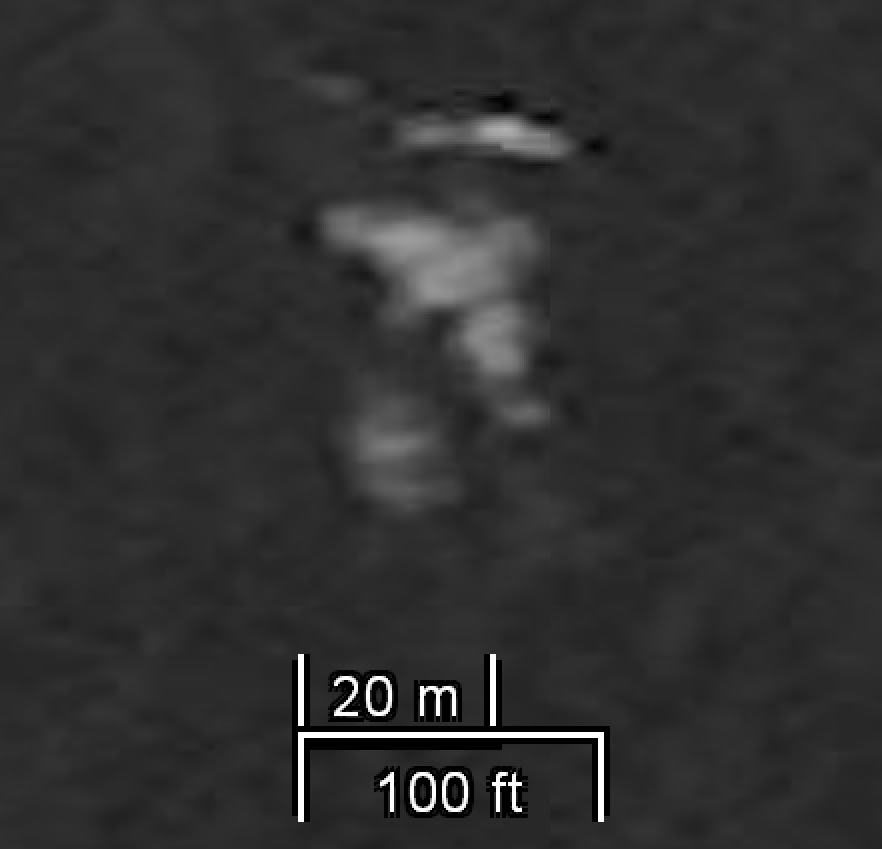
This satellite images below (see 15 in map above) shows where I believe the debris field of MH370 was last spotted 8 days later on March 16, 2014 near northern Sumatra in the Northern Indian Ocean approx. 423 KM south/west of Raja's sighting on March 8th. I believe the plane did a control ditching and landed relatively intact with some structural damage when Raja saw it but afterwards the airframe broke apart into these large pieces because of the mechanical stresses on it's airframe caused by the ocean waves as it was drifting and the initial impact damage to it's airframe. The image shows 4 objects that all have geometric shape, scale, and appearance consistent with parts of a B777-200ER aircraft.
The probability of finding in a satellite image 4 random objects like this floating in the ocean, of this size, shape, and appearance and they are not from an aircraft seems very improbable to me. These must be parts from an aircraft but the question is, are they from MH370? Unfortunately because of the resolution of this satellite image (50cm x 50cm) it's impossible to tell with certainty whether it's MH370, or not, but based on visual analysis of each piece and size comparison with B777-200ER aircraft dimensions they very well could be pieces from this aircraft.
If this location is correct it would corroborate that Raja's sighting is true and that the Inmarsat data was completely wrong and was most likely being spoofed from another aircraft because this location is nowhere near the 7th arc where MH370 supposedly transmitted it's last ping based on that data.


You can actually see from this enhanced images some of the red and blue livery on this fuselage piece. Definitely could be our plane.
It is my hope by writing this blog that some future Ocean Explorers who can do deep sea sonar scans will be inspired or intrigued enough by my research to go check out and scan this area of the Northern Indian Ocean and see if they can find any of the debris pieces that were captured in this satellite image.
Eventually these larger pieces would become water logged and sink somewhere downstream from where this image was taken which is where I believe we will find the wreckage of this plane. Only the smaller pieces that remained buoyant drifted all the way to Africa.
These pieces of debris captured in this satellite image I believe are the key to unlocking the mystery of MH370 and finding out the real truth about what really happened to this plane. If we can find those pieces and confirm they are from MH370 that would be a miracle.
The Debris Evidence
This is where those 30+ pieces of debris from MH370 found in Africa originated from and why it took over 16 months for the pieces to start arriving in Africa from this location, they were drifting from the Northern Indian Ocean (NIO). This drift simulation below shows how debris would have drifted over time from this location and why it took 16 months for this debris to reach the shores of Africa.


I believe the hijackers on-board MH370 were stowaways hiding in the Main Equipment Center (MEC) compartment (also called avionics bay) of the plane and I also believe that all 239 passengers and crew on-board this plane were completely innocent, with regards to the hijacking, and could not have possibly pulled off such a sophisticated hijacking like this with decoys. Someone else had to be on-board that plane and in this MEC compartment to disable those systems.
It's possible there may have been a team of 2 to 4 hijackers hiding in there. This may be the most plausible method in this case if we consider a third party hijacking scenario like mine with sophisticated state actors as the hijackers. They would have been a highly trained team to do such a type of hijacking of a plane and to disable it's systems and at least one was a trained pilot who could fly the plane as well.
This compartment is easily accessible through an external hatch below the aircraft and is pressurized as well as climate controlled during flight because of the equipment. I believe the hijackers were able to get on-board this plane before take-off, possibly disguised as maintenance technicians, and were able to first disable the ACARS system (17:07 UTC) then the VHF/HF coms, after Captain Shaw's last signoff message (17:19 UTC), from within this maintenance compartment by pulling circuit breakers on the maintenance CB panel in this MEC compartment.
I believe they initiated the hijacking from this compartment and then entered the cockpit by pulling the circuit breaker for the cockpit's electronic door lock (located also in MEC compartment) and then they entered the flight deck through the upper hatch and opened the cockpit door which is right next to this hatch. Assuming these hijackers were armed they may have taken control of the cockpit this way and immediately switched off the transponder (17:21 UTC) from the cockpit. This would have happened within two minutes of Captain Shaw's last sign off message "Good Night Malaysia 3-7-0". They may have coerced the pilots into doing what they wanted or took complete control of the plane themselves and locked the pilots out of the cockpit or disabled them.
After storming the cockpit and taking control of the plane they then went to the overhead locker in the aft cabin compartment where the Satellite Data Unit (SDU) is located and disabled it from there (18:03UTC) . Once that was done the plane flew radio silent for the rest of it's flight and the hijackers were in complete control of the plane. The may have also used an Electronic Warfare (EW) jamming device to jam all cell phone signals as well.


The Decoy Aircraft
I believe MH370 was hijacked in a military operation by some powerful state actors whose objective was to hijack this plane at all costs and retrieve the stolen sensitive military cargo that was being smuggled illegally onboard this aircraft into China. They also had to dispose of the passengers and the plane so there would be no witnesses or evidence to this dirty deed.
The decoy aircraft I believe was another B777-200ER aircraft with similar engine performance as MH370 (9M-MRO) that was being flown under satellite remote control, pinging every hour, and I believe it had a paint job to look identical to MH370. One possible such aircraft that they may have used may have been an old Malaysia Airlines plane such as 9M-MRI (N105GT). I saw it listed as stored in 2014 then listed as scrapped in 2015 and was owned at the time by a Florida based company GA Telesis LLC an aircraft, leasing, distribution, and maintenance company. I believe this plane (N105GT) may have been the decoy plane that was scrapped in the Southern Indian Ocean around 43S Lat.

This decoy plane was seen in Western Australia that day in the afternoon by several witnesses , flying low with no one on-board looking identical to MH370 several hours after transmitting that false data in the SIO. These witness sightings to me prove the existence of the decoy and that it looked identical to MH370. What a coincidence, on the day MH370 goes missing there just happens to be another plane flying around Western Australia, flying low, with no one on-board, looking identical to MH370. I don't believe this is just a coincidence.
I believe this decoy then flew back to Pearce Air Force Base in Australia at low altitudes evading radar detection from civil authorities but was seen by those ground witnesses in Western Australia. I believe this decoy plane did not crash at 00:19 UTC and it was a fully fueled B777-200ER aircraft that was capable of flying for over 11 hours. I believe the decoy landed at this base and was unloaded and refueled and then flew back out to the SIO to be ditched there. This of course would implicate that the Royal Australian Air Force (RAAF) may also have been part of this cover-up and hijacking.
Boeing Uninterruptable Auto-Pilot (BUAP)
The Boeing Uninterruptable Auto-Pilot (BUAP) was patented by the Boeing Company after 9/11 to give the US Government a means to take remote control of a hijacked plane via a remote control link. This technology would make all pilot controls from the cockpit useless and the plane could be flown by a remote pilot via a satellite link. I have no idea if this technology was on-board MH370 but if it was installed sometime prior to flight this may explain how MH370 may have been hijacked as well and controlled by a remote pilot.
From my understanding of this patent the operation of this system requires that there are command codes stored on-board the vehicle which can be activated through a remote satellite link that will cause the "vehicle", in this case an aircraft, to operate in a different mode of operation ignoring pilot controls and commands from the cockpit and overriding these controls via a remote link controlled by a remote pilot.
In other words a BUAP system may just be a software upgrade done on the Airplane Information and Management System (AIMS) which is the brain of the B777. It's this system that is actually flying the aircraft and if it's operating system is modified with these commend codes then in theory you can make this system run in a different mode of operation through software. This is how a B777 could be remotely hijacked according to my understanding of this patent and it may just be a simple software upgrade to the AIMS computer to do this.
Of course any modification like this to the AIMS OS software would have to have been developed and tested by Boeing and Honeywell (the manufacture of the AIMS system) before it could ever be implemented and tested on a passenger aircraft. Assuming they developed and tested this technology after 9/11 then maybe all that is required to do a remote hijacking on an aircraft is a simple software upgrade to the AIMS OS software with these command codes embedded in the program, and no special hardware is required, everything can be done through software.
Simply put if you can control the AIMS computer through the satcom link you can control the aircraft. Anyone who has worked in electronics, avionic systems, or programming, as I have, will understand this is probably the easiest and most practical way to do this remote control method by simply modifying and adding code and making the AIMS system run in a different mode of operation (remote control) that it was never originally designed to do.
In theory this may be how this BUAP system works and if this is the case then it's maybe possible that this software upgrade may have been installed on MH370's AIMS computer prior to flight. I am not saying this was done but I am just throwing it out there as a possibility.
The truth straight from the horse's mouth. Evidence of the Hijack of Malaysian Airways Flight MH370 using the Boeing-Honeywell uninterruptible Autopilot by Captain
Two Plane Diversion Theory
By fabricating false radar data and Inmarsat signal data this would make the experts and public believe MH370 crashed into the Southern Indian Ocean nowhere near where they actually ditched it and also this false data would help to discredit any eye witness reports which contradicted this data. While MH370 was flying west towards the Maldives at low altitudes evading radar detection the decoy aircraft was flying out to the SIO creating false Inmarsat data making it seem that MH370 was flying out there.
This is why the 3 year search for this plane in the Southern Indian Ocean based on the Inmarsat data has been nothing more than a 3 year, $300 million, wild goose chase based on fabricated Inmarsat data created from a decoy aircraft. This is why after 3 years of searching they never found a single trace of MH370 debris or it's wreckage anywhere down there because MH370 never flew down there.
.jpg) |
| MH370 Predicted Flight Route (DECOY). |
What was eventually ditched in the Southern Indian Ocean (SIO) at the 43S latitude was the B777 drone decoy (N105GT) that transmitted the false and misleading Inmarsat data emulating MH370's Airborne Earth Station (AES) ID 35200217.
By flying this decoy out into the SIO pinging the satellite every hour with MH370 ID this would create the illusion and false data that is was MH370 flying out to the SIO misleading authorities and Inmarsat employees into believing that this plane was MH370. This deception has worked very well and because of this data many still believe today that MH370 will one day be found somewhere along that imaginary 7th arc where it supposedly transmitted it's last ping.
I believe that a piece of aircraft debris that was found on Kangaroo Island in Southern Australia back in 2015 is a piece of this aircraft and confirms that whatever plane that crashed down there it was not MH370.

Below is a composite of satellite images of what I believe are 3 pieces of debris from this decoy plane. Originally I thought they maybe pieces of MH370 but as I did more research and learned of more eye witness reports I came to the realization that this plane was just a decoy and that's why the Inmarsat data (7 pings) is completely wrong and misleading. It's not the mathematical analysis of the data done by the experts that was wrong, it's because they didn't realize they were analyzing data transmitted from a decoy.


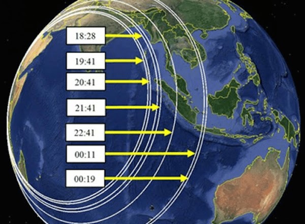
The Radar Data
I am convinced from my research that the radar data that was provided to the public by the Malaysian Government in their final report, which purportedly showed MH370 allegedly turning back and flying across the Malaysian Peninsula and then north up the Malacca Straits, was in fact actually the radar path of a fighter jet (yellow track) that was being used as a decoy to fly across this airspace and distract the attention of ATC controllers away from where MH370 (red track) actually was flying and make them believe this fighter plane (yellow track) on their primary radar was MH370. They then switched decoys in the Malacca Strait and it is the B777 decoy drone (green track) that flies out to the SIO transmitting the false and misleading Inmarsat data.
I believe that the B777 drone may have taking off from Butterworth AFB (the same jokers who gave us this bogus radar data) where it flew out at low altitudes over the Straits Malacca before ascending and appearing on radar. The fighter jet may have also returned to this military base after dropping off radar.


What version of their official RMAF radar story do we believe?
The RMAF who gave us this bogus primary radar data, and originally changed their official radar story 2 times on this, told us we should just discard the altitude data because apparently their state-of-art military radar system was very badly calibrated that evening and all the altitude measurements they measured that evening were completely off thus this data should be ignored. Of course it must be ignored because if this altitude data is correct then this plane cannot possibly be MH370, therefore the official story is a lie, and they know it, and they are covering something up.
This is why the RMAF never bothered to get off their asses and send up fighter jets to chase this unknown aircraft in their airspace BECAUSE THEY KNEW THIS UNKNOWN PLANE WAS FRIENDLY! THEY KNEW WHAT WAS GOING ON!!!
Never did the RMAF give any reason or proof as to why the altitude data they recorded that evening was in error. No additional primary radar data from other flights that evening were ever published from them so we cannot know for sure or verify if what they are saying is true or not. Why did they change their radar story so completely from the original version in 2014 to this current version in 2015? How could they have been so incompetent not to have checked and interpret their own radar data correctly the first time before publicizing it? To me it looks like they had to change the truth to fit the lie (Inmarsat data).
If this altitude and speed data is valid, which I believe it is, then this would completely prove their theory is wrong and prove they are deliberately deceiving the public with this radar data by saying this plane turning back over the Malaysian peninsula was MH370 when they know it cannot possibly be because a B777 cannot fly at those recorded altitudes.
My analysis on this is there is nothing wrong with the altitude data the RMAF recorded that evening on their radar and this data proves this plane seen on primary radar turning back heading towards Penang was not MH370 and more likely was a fighter jet which would make the RMAF complicit in a cover-up. This whole scenario that MH370 was seen turning back on primary radar after the waypoint IGARI is a complete lie, and a myth, to deliberately cover up the truth of where this plane actually went after it's transponder was turned off.
It's clear to me based on ground witness reports that after MH370 transponder was turned off after the waypoint IGARI the plane soon after went into a nose dive, creating a sonic boom heard by witnesses on a beach, and flew west at low altitudes trying to evade radar detection by flying along the Malaysia/Thailand border being seen only by a few ground witnesses at the time but remaining for the most part undetected by radar.

I believe this initial radar sighting of a low flying aircraft reported by RMAF officials a couple days after the plane disappeared near the island of Pulau Perak at 2:40am (18:40 UTC) is correct and confirms the witness sightings of where MH370 was flying that evening, near the Malaysia/Thailand border and nowhere near Penang and contradicts the Inmarsat data. The RMAF never published this radar data, I wonder why.
Due you see their dilemma? If that radar hit near the island of Pulau Perak was MH370 this would confirm the witness sightings and contradict the Inmarsat data so they had to change their radar story to fit the Inmarsat data. They needed to get their lie straight. It's like the hijackers are giving us this misleading radar data because they have to conceal the truth about what they did and make their lie plausible.

This image (above) which purportedly shows the radar blips that the RMAF picked up that night on their radar screens as the plane, presumed to be MH370, was flying north in the Malacca Straits. Why is there a 5 minute gap in the radar coverage here (white circle)?
Of course this could be just one plane that temporally dropped off radar flying at low altitudes flying below 4800ft and that's why they had no radar data for 5 minutes at 02:07- 02:12 (18:07-18:12 UTC). But why would they do that, disappear and then reappear on radar? That makes no sense to me and seems to defy logic. No blips during this 5 minute time period means they don't know exactly what altitude the plane was at during this time. They can only say it was below 4800ft during this period because it was below their radar detection capabilities in that area.
Could we be looking at two different planes here? Could the first half of this track be a fighter jet that drops off radar and then 5 minutes later a B777 drone appears on radar and it's that plane that flies out to the SIO? This would explain the difference in speed/altitude performance that we see in the radar data before and after this time gap. The hijackers were doing a switch of planes at this time. That's why the fighter jet needed to descend to land somewhere while the B777 drone decoy ascended appearing 5 minutes later on radar on the same flightpath so it would appear to be the same plane. This is where I believe they switched decoys from a fighter jet to the B777 drone and it took them 5 minutes to do this. This is why I believe this gap exists in the radar coverage and why the performance data of this aircraft seemed to have changed to a more stable flightpath like a B777 afterwards. We're staring at radar data in this photo (above) from two different aircrafts and neither one is MH370.
This story was first made public by some unnamed US sources which stated that F/O cell phone made a connection to this cell tower in Penang at 0152:27 MYT (1752:27 UTC). If this were true then based on these test results below this would be indicative that MH370 was flying at altitudes below 8000ft for a connection to be realistically possible. Based on the recorded altitude data of the aircraft seen on primary radar flying past Penang at that time it was flying at altitude of 44,700ft. No way could a 3G cell phone at that time could have made a connection to this cell tower from that altitude, impossible. I tend to think this was a planted story made up by US officials in order to make us believe in their radar lie.

Of course experts will argue that it's the radar altitude data that is incorrect because the RMAF told them so. If that were true it would mean the calibration error (inherent error) of their radar must have been greater than +/-36,700ft. That seems to unbelievable to me that their military radar would be that inaccurate. I say show me the proof the altitude data is wrong otherwise we must assume this data is accurate therefore no connection was possible from this aircraft at that altitude 44,700ft.
If a connection was made this would be a strong indication that MH370 was flying at low altitudes (below 8000ft) at this time and would be more consistent with the witness reports not the radar data.
However in my theory the more likely time of this connection would have been closer to ~18:20-18:25 UTC when MH370 would have been at it's closest (~50nm) from that cell tower in Penang flying at low altitudes (below 8000ft) along my flightpath. In my theory the F/O cell phone could have made a connection during this time period but not at 17:52 UTC because I believe the plane was east of Tumpat at this time too far away for a connection in Penang. If you told me the connection happened at a cell tower in Kota Bharu at that time that would fit my theory as well.
The timing doesn't fit with the witness sightings so I don't know if this story is true, or not, or is the timing somehow wrong or the location. Either case it does not seem to fit in with my theory nor the official theory as well so I tend to think this story is bogus or somehow in error. I do know that the cell signal didn't come from that fighter jet at 44,700ft.

Did someone change the timestamp, or location, of this cell ping in the Telco service provider logfile to make it fit their radar lie?
Maybe this cell ping did occur but from another cell tower or just not at that time (17:52 UTC)? I honestly believe though that this may be the case here, someone modified the timestamp or location in the Telco logfile to match with the plane seen radar, when it was closest to the cell tower, and make it appear that cell signal came from that plane. That's how clever I think these hijackers were. Of course I have no proof of this just speculation but if my theory is correct then this would explain it. I believe this cell connection could be true because it is consistent with the witness sightings of a low flying plane but I believe either the timestamp is incorrect or the cell tower location is wrong because that data is contradicting the reality of what the witnesses saw.
We do not know which model of cell phone the F/O had or which service provider he was with at the time. If we had that information it would give us a better indication of what the plane's altitude could have been at that time.
We can conclude from this test data (above), if this cell connection is true and the logfile is correct and not modified, is that MH370 would had to have been within 50 nm of this cell tower in Penang, or less, and had to be flying at altitudes below 8000ft for a cell phone connection to be realistically possible at this time 17:52 UTC. This is more consistent with the witness sightings of a low flying plane than this plane flying at 44,700ft. No way did the cell signal originate from that plane seen on radar and if true it confirms that MH370 was indeed flying at low altitudes which supports the eye witness reports.
This one piece of data (timestamp 0152:27 MYT (1752:27 UTC)) seems to contradict the time of the sightings of these eye witness reports which leads me to believe that this timestamp is maybe incorrect, or the location is wrong, or this whole story is bogus because I am certain reality is what the witnesses saw that night and any data that contradicts this reality is suspect in my opinion.
There is no way MH370 could have been near enough to that cell tower in Penang at 17:52UTC and then be seen 8 minutes later by that farmer in Tumpat at 18:00 UTC on the other side of the Malaysian peninsula. So if you believe the cell connection is true then the farmer sighting has to be false. This cell connection story is another piece of evidence, along with the Captain's sim data, that I have come across that seems to have been fudged, or fabricated, to me.
This other data (radar/Inmarsat data) I believe is authentic data in the sense that it is actual data from aircrafts, and was not manipulated in anyway, but it was not data created by MH370.
I am certain the eye witnesses saw the true reality of where MH370 was at this time and their timings are relatively correct (+/- 5 mins) and any data that contradicts these facts is suspect to me and is most probably bogus evidence, as you will see in this next section.
Here is a link to Inmarsat data log file for MH370. Here is the unredacted version in this Excel log file.
As MH370 was flying out to the Maldives another decoy, a B777 drone, was flown out to the Southern Indian Ocean pinging the Inmarsat satellite every hour using MH370 AES ID to fool Inmarsat and the authorities by creating the illusion that it was MH370 flying out to the SIO. This would give these state actors a solid cover and use this data to disprove any witness reports to the contrary and make it seem impossible that MH370 could have been in the Maldives during this time period.
If the witnesses claims in the Maldives are true then there is something very wrong with the Isat data and mostly likely indicates the data was spoofed by another plane.
The only proof the authorities have that MH370 flew into the SIO is the data packets Inmarsat received on these 7 pings which contain the 24 bit hexadecimal AES ID (35200217) address code of MH370 indicating that those the signals were coming from MH370.


I believe that this part of the Inmarsat data (18:25 - 00:19 UTC) those 7 pings was being transmitted from a different aircraft (B777 decoy) spoofing MH370 sat signal which switched on it's SDU at this time (18:25 UTC) using the same AES ID as MH370 (35200217) and did not have it's ACARS switched on in order not to give away it's exact position.
I believe the SDU on MH370 was permanently switched off and disabled at this time as well as the ACARS, VHF/HF coms and transponder making MH370 fly radio silent for the rest of it's journey.
If I am right about this it would mean that when Malaysia Airlines was trying to call MH370 at 23:13 UTC it was actually the sat phone on the B777 decoy that was ringing. That's why no one answered because probably no one was on-board that plane and if there were people on-board this decoy I don't think the hijackers would have answered it anyways.
My belief is that at 00:19 UTC the decoy plane went into a nose dive while it was transmitting it's last ping by rebooting it's SDU one last time before being switched off permanently. This would also explain the descending BFO measured values observed on this last ping because of this doppler effect caused by the planes rapid descent velocity at this time.


Inmarsat's measured Burst Timing Offset (BTO) values for MH370
This is why MH370 will never be found in the SIO and why not one piece of debris or wreckage has been found down there in the entire three years that they have searched. They're searching an imaginary 7th arc created from the decoy's last transmitted signal position at 00:19 UTC and they're convinced MH370 transmitted that data because that 24 bit AES ID contained in the signal data packets supposedly tells them this.

I believe these state actors used this decoy aircraft to create this false Inmarsat data to purposely mislead authorities on a wild goose chase, with a bunch of electronic breadcrumbs (pings), making them believe MH370 flew into the SIO and nowhere else. This data would gave these state actors the perfect cover for their crime and would make it seem impossible to authorities that the plane could have been anywhere else but in SIO because that data tells them this. This data would also be used to disprove any witness reports that contradicted this bogus data.
The Satellite Imagery Data
What originally led me to start theorizing there may have been a second plane involved was my research I did into satellite imagery data. These satellite images came from the satellite company DigitalGlobe (now Maxar) which had at the time a public crowd sourcing campaign, called Tomnod, to help find MH370 debris using their satellite images that were taken over the Indian Ocean in the weeks following MH370's disappearance. The satellite images have a resolution of 50cm x 50 cm so fine details are limited in these images.
After reviewing hundreds of satellite images of possible debris pieces myself and of those other researchers over a period of a year I came across two locations in the Indian Ocean which in my opinion seemed to show possible B777 aircraft debris. One location was in the Northern Indian Ocean off the coast of Sumatra and the other was in the Southern Indian Ocean around 43S latitude.
Location #1 Sumatra (MH370 location)
So who did this? Who were these state actors?
Who had the technical capabilities and deep pockets to have pulled off such a hijacking? Who had the technical capabilities and prior knowledge of the Inmarsat network to have spoofed their network? Who has the capabilities to fly a B777 drone under satellite control into the SIO? Who has the ability to fly fighter jets? Who has the power to make other countries militaries and governments seemingly help cover this up?
Based on the brilliance of this deception I only have one suspect(s), these guys, the CIA & US Department of Defence (Inmarsat Government's favorite customer) under the direct order of President Barack Obama with the help of his golf buddy, and friend, Prime Minister Najib Rizak who helped him cover-up this unspeakable truth by feeding the public bogus Radar/Inmarsat data that wasn't even created by the plane that went missing and saying MH370 ended in the Southern Indian Ocean.

The official story is a scam. I believe President Barack Obama ordered that plane hijacked and it's sensitive cargo retrieved no matter what the cost and also to teach the Chinese Government a lesson about their hacking activities and the consequences of stealing US military technology. He may have also wanted to give them payback for those two dead ex-Navy Seals on-board the Maersk Alabama. I believe he did this to protect the national security interests of the United States and this was a covert military operation which to this day is still classified.
This may have been the toughest decision of his Presidency, and like all other Presidents before him, sometimes they need to make extremely difficult decisions for the greater good of their country which sometimes ends in the loss of innocent lives. Lets us hope the Chinese Government, who I believe instigated this event, has learnt their lesson as well.
Why are matters concerning the disappearance of commercial passenger airplane (MH370) considered a "properly classified matter" within the US Government? More info here on FOIA request.


I am convinced the ground witnesses that day who came forward and told their stories to the police and media are telling us the God's honest truth and the true reality about where MH370 flew that night and I am certain that both the radar data and Inmarsat data that were made public by the Malaysian Government was not data from MH370 at all but rather data created from decoys to mislead the public and the civil authorities away from this unspeakable truth.
This was obviously a military hijacking of a civilian airliner and a massive cover-up!
I believe the passengers, crew, along with their luggage, and the rest of the cargo, were brought back to the US military base Diego Garcia out there in the Indian Ocean and I do not know if anyone died on that plane. I also believe that the stolen 89Kg cargo that was put on-board MH370 at the last minute was returned to it's rightful owners at that US drone base in Seychelles, Africa.

United States Military Base, Diego Garcia.
My hope is that those civil authorities today who want to still find the truth about MH370, as I do, will consider my research and consider the possibility they may have been duped by the Inmarsat data and the radar data they were given to find this plane and consider searching elsewhere for this plane based on the witness reports and satellite imagery data that I have highlighted on this blog.
We can only hope and pray this will never happen again.
Ken St. Aubin
Twitter @kstaubin
Footnotes:
1- Satellite Imagery Metadata
I just wanted to add here the satellite image info (metadata) for the all the debris pieces shown on this blog in case any future explorers or researchers would like to purchase and obtain the original satellite imagery data from Maxar (formally DigitalGlobe) website.
Sumatra Location satellite Image Metadata
The debris field in this satellite image is located at Lat 4.62N, Lon 90.72E and the catalog number is 10504100102E4F00. Tomnod Map 163x4rye


SIO Location Satellite Images Metadata
Nose Cone piece is located in this image at the coordinates -43.4994S Lat, 95.7869E Lon and the catalog number is 103001002EC7F600. Tomnod Map 18sx2gy67.


Image courtesy of Patrick Tissot.
Fuselage piece is located in the image at the coordinates -43.9317S Lat, 96.1227E Lon and the catalog number is TBD. Here is a screenshot from Tomnod image of this piece that was captured on March 26th, 2014. I have not as of yet been able to find the Maxar catalog number for this satellite image. If any one knows please forward to me in the comments, thanks. Tomnod Map 18rx1uy37.


Here's a PDF document published by E. Fortuin and C. Ponte on this debris.

2-MH370 Radar Anomaly and the Mike Mackay sighting
Watch this Youtube video of MH370 radar that night and watch for the strange anomaly at the 0:04 mark. What was this strange aircraft that appears on radar then accelerates at hypersonic speed (I estimate MACH 6) then deaccelerates and disappears from radar. Was this a glitch in the ADS-B radar coverage of that area or was this a hypersonic aircraft spoofing the the call sign of passenger plane?
Could this be the burning plane that oil rig worker Mike Mckay saw coming towards him that night? This plane was flying towards his direction on that oil rig in the South China Sea at the time of his sighting so this anomaly could explain his sighting but what was this aircraft? Was it some sort of prototype hypersonic military aircraft like the SR-72 and he saw the afterburners of it's jet engines or is it just a glitch in radar coverage? Based on Mike's sighting I'm not so sure that this was just a glitch.


If this radar anomaly was a hypersonic jet aircraft , like the SR-72, and was somehow involved in the disappearance of MH370 then I have a pretty good idea who these state actors were.

This SOFA agreement gives US forces the capability to access and use Maldivian airports and seaports for military purposes and operations when deemed necessary. If MH370 was hijacked in a military operation by the US they may have invoked this agreement with the Maldivian Government and needed to use two of their airports (Male/Thimarafush) to land MH370.
If this was the case this would imply that the Maldivian Government at that time also had direct knowledge of this military operation and actively covered this up which maybe is why they appeared to have lied about that low flying plane seen in the Maldives that day. Were they covering up the fact that this plane was MH370 seen in their airspace that day?
Maybe this is why researcher Blaine Gibson wasn't very welcomed in the Maldives by the authorities when he went there looking for debris, asking questions, talking to witnesses, and why he had threats on his life, because these authorities didn't want him snooping around down there and finding out the truth, perhaps?
I am certain that if MH370 was hijacked and did land in the Maldives this is something no one in the Maldivian Government, at that time, would have wanted known to the public and is why they tried to cover this up by telling us it was another plane. I believe people who still do know the truth are keeping silent because they are sworn to secrecy or are still fearful for their own lives to this day.
4- Who could have had the technical know how and prior knowledge of the Inmarsat network and were capable of spoofing their network using another aircraft?
Maybe these guys? Inmarsat Government's favorite customer, the US military and it's government agencies perhaps?
Read this article about a U.S. spy plane impersonating a Malaysian airplane in 2016 to fool the Chinese. If they can spoof the the Mode-S transponder signal this way they can also spoof the Satcom signal as well.
5- How's it possible these guys saw nothing on their OTH radar and Space Surveillance Network?


They must know something.


This is pure speculation on my part but I believe it may have been a drone command and control unit (like this one below) that the Chinese Government may have had an intense interest in acquiring this kind of drone technology. Since there is a US drone base in Seychelles it would have military hardware like this that the Chinese were maybe after.

8- Captain Zaharie Shaw's Flight Sim Data.
I believe this flight sim data (red track) reportedly found on Captain Shaw's home flight simulator that shows a flightpath out to the SIO was planted evidence by the CIA in a feeble attempt to make it seem that he premeditated this hijacking and murder. I believe the CIA planted this evidence on his computer then they back dated the sim files to make it look like he did this flight sim prior to the event. I then believe they brought his flight simulator back to the FBI crime lab in Washington for analysis so they (FBI) would discover this bogus flight sim evidence and tell the public. Any evidence that comes from US sources is suspect in my opinion in this case. They obviously weren't good at the BTO math either.
Read this interesting research done on a flight simulator. It's not possible for the .FLT coordinates file to have been saved in the Win7 Shadow Copy directory where the FBI reportedly found them on Captain Shaw's flight simulator. Someone must have planted this coordinates file in that directory.

9- The missed cell phone call
This story appeared in the latest Netflix docuseries on MH370 which this girl claims she received a missed call from her father who was on-board MH370. If the story is true it would mean that MH370 must have been on land somewhere in order for her father to have made that call. This fact alone disproves the official theory completely and also the shootdown theory as well. MH370 could not have crashed into the Southern Indian Ocean (SIO) nor have been shot down in the South China Sea (SCS), it had to have been on, or near land somewhere, for her story to be true.


This comment has been removed by the author.
ReplyDeleteWould it be possible for you to "prove" that, from a certain time to the end, the three orbs rotate within a common 2-dimensional plane? (It looks like that in the video).
ReplyDeleteI would also be interested in the approximate diameter of the spheres, as well as the temporal behavior of the distance of the spheres from the center of rotation.
If you continue to do this research unforeseen consequences will come mate. This will be my last and final warning.
ReplyDeleteDiego Garcia requisitioned the Australian merchant fleet to send an empty cargo ship called The Ocean Shield to "Move and transport personnel " Just after the event. Regarding the passengers? I presume you have seen the footage of the bodies at the crash site of MH17 that went down in Ukraine a few months later? Long dead decomposed (Mostly Asian) bodies, drained of blood and steeped in formaldehyde? Luggage consisted of winter cloths ( MH17 was flying to sunny Malaysia. MH370 was flying to cold wintry Beijing. MH17's downing by alleged pro Russian separatists sparked a massive money and arms injection in to Ukraine ( and US arms companies). A Ukrainian friend of mine told me that trains full of armaments, would pass his house at night and were so long, they took 10 minutes to pass. If these were bodies of the Freescale passengers and their families stuffed in to the cargo hold of MH17, then were they a second layer of the false flag downing of the plane? Main reason was to blame Russia and get the arms deals going for US arms companies but, was putting the bodies of the Freescale passengers from MH370 on board MH17 a message to taunt the Chinese government? USA took the plane down. USA knew that some forms of alternative media would release the footage of the bodies but Main Stream would not. China would become aware of the bodies. Was it an insidious message to China and a warning. 'Look what happens to double agents or people who cross us or steal and sell our tech? Go to 31 mins in and watch to the end, all Katia's video footage and photos of the bodies at the crash site, are here, its a long segment, runs all the way to the end of the video https://www.bitchute.com/video/Hr4Z93piCe1p/
ReplyDelete