Possible MH370 debris sighting in SIO
Satellite Imagery data
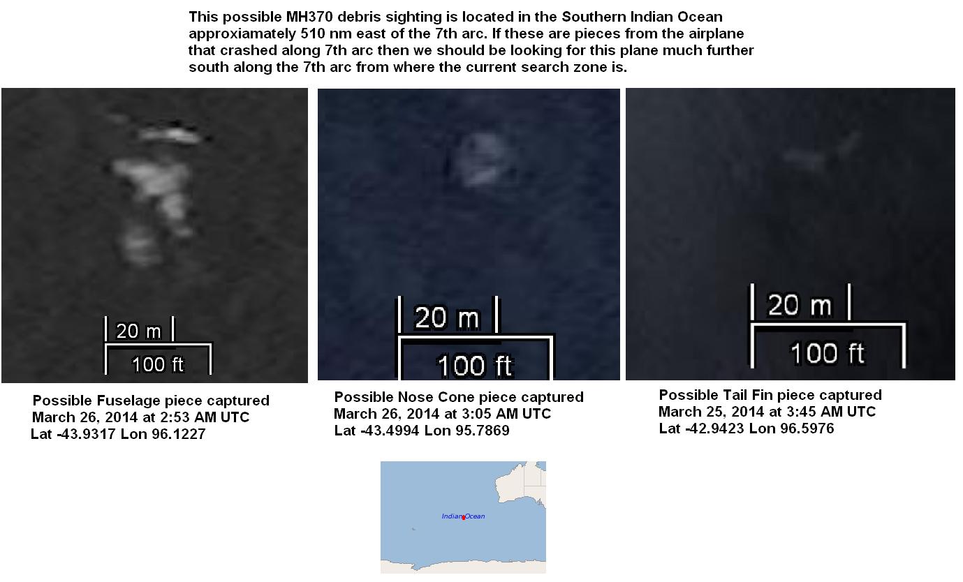
Here is some satellite photographic imagery of possible MH370 debris captured in the Southern Indian Ocean. (Most of the links are no longer active because Tomnod has archived all this data unfortunely, however I have made screen captures below.)
Click on "X" in intro message to see maps
Tail Fin? http://www.tomnod.com/campaign/mh370_indian_ocean/map/18bxhyc0
Cockpit ? http://www.tomnod.com/campaign/mh370_indian_ocean/map/18sx2gy67
Fuselage? http://www.tomnod.com/campaign/mh370_indian_ocean/map/18rx1uy37
Fuselage ? http://www.tomnod.com/campaign/mh370_indian_ocean/map/18sx2sy79 …
Wing http://www.tomnod.com/campaign/mh370_indian_ocean/map/18sx2wy7q …
Additional debris maps
http://www.tomnod.com/campaign/mh370_indian_ocean/map/18rx25y26
http://www.tomnod.com/campaign/mh370_indian_ocean/map/18rxfy8i
http://www.tomnod.com/campaign/mh370_indian_ocean/map/18rx1py2s
Metadata and map locations for these image maps 18s and 18b
18b - https://t.co/72uWjwoAtL
DigitalGlobe Imagery
Here are some comparison images between the Tomnod image maps online and the maps listed on the DigitalGlobe website. This comparison of cloud formations proves that they are both from the same image and the Metadata of the image tells us the debris's approximate location.
Remember that dimensions of these objects are approximate due to perspective and veiwing angle, you cannot get a precise measurement because of this but we can see that these objects are well within the ballpark measurements (see Figire 15) and geometric shapes to make them qualify as potential 777-200 debris parts.
Figure 2: Possible Nose Cone

https://www.dropbox.com/s/xb4nlra4lr6vnk7/MH370_debris_in_SIO_v6.PNG?dl=0
Figure 3: Possible Tail Fin

https://www.dropbox.com/s/xq76eehp013s7a1/MH370_debris_in_SIO_v5.PNG?dl=0

Map # 18rx1uy37 https://www.dropbox.com/s/gzakhbspk3vk59n/MH370_debris_18r_v2.jpeg?dl=0
These images courtesy of Patrick Tissot

https://www.dropbox.com/s/lkki3dcwx1jpjwu/Photo%20D.JPG?dl=0

https://www.dropbox.com/s/iwnrj49yc45audb/Photo%20C.JPG?dl=0

https://www.dropbox.com/s/t8nc9vl1tiq5l0r/Photo%20F-2.jpg?dl=0

https://www.dropbox.com/s/tnnay5su3mzob49/Photo%20B.JPG?dl=0

https://www.dropbox.com/s/s15rk2sc0tkziuj/Photo%20E.JPG?dl=0

https://www.dropbox.com/s/73vckct2j5dq3hq/d%C3%A9bris3.jpg?dl=0

https://www.dropbox.com/s/j03tv0wgf0ee36p/drift.jpg?dl=0

Map # 18sx2vy7q https://www.dropbox.com/s/ihx4enkp0v5wotd/debris%20secteur%20aile.jpg?dl=0
Additional objects spotted in maps 18e (images courtesy of Maggy Trust)

https://www.dropbox.com/s/sa8xra3uupx0nug/18e_debris_v2.jpeg?dl=0

Map # 18ex14y36 https://www.dropbox.com/s/7e5hd57s0tab85i/18e_debris_v1.jpeg?dl=0
Additional objects spotted in maps 18r (images courtesy of Becky Corbett)

Map # 18rx3ay36 https://www.dropbox.com/s/k9vg8p46nkdrheh/MH370_debris_18r_v1.jpeg?dl=0
Additional debris images courtesy of Patrick Tissot

Map # 18bx7y67 https://www.dropbox.com/s/ab0ob6afo0g1vjl/ktO5adI5.jpg%20large.jpeg?dl=0

Map # 18sx9y31 https://www.dropbox.com/s/l8c4zf3pso3wk3r/i_lJiCV9.jpg%20large.jpeg?dl=0

Map # 18sx9yfs https://www.dropbox.com/s/hrrtevb8yiblsyt/qBnodNuJ.jpg%20large.jpeg?dl=0

Map # 18sxcyfp https://www.dropbox.com/s/kpztrlj7o4ucvtc/0oizOwHr.jpg%20large.jpeg?dl=0

Map # 18sxcylj https://www.dropbox.com/s/jebjume0k7rs7hs/X6g_Z7IC.jpg%20large.jpeg?dl=0
Additional objects spotted in maps 18r (images courtesy of Elizabeth Fortuin and Carlos Ponte)
Here is an excellent debris sighting report sent to me by Elizabeth Fortuin and Carlos Ponte documenting debris pieces they have found in various Tomnod image maps.
PDF Link: Objects of interest found on Tomnod
Figure 4


FIGURE 10: 777-200ER/-300 dimensions

FIGURE 11:

FIGURE 12: Location of debris in map 18b

FIGURE 13: Location of debris in map 18s

FIGURE 14: Here is an object captured by DigitalGlobe, and publish by the Australian Government, from March 16th, 2014 just to the West of the other debris pieces on this blog. If this piece is associated with these other debris pieces it indicates that the debris field was moving from West to East along the 43S Latitude.

Figure 15: Here is a graphic published be the Australian Government showing where several debris fields were spotted in March 2014 by satellite.

Figure 19: MH370 Contrails in Visible Images Taken After Sunrise in SIO

FIGURE 20

FIGURE 21

FIGURE 22: Location of Tomnod Maps

FIGURE 23: Location of debris

FIGURE 24: Forward drift model.
FIGURE 26: A trawler skipper’s memory from the deep dredges up intriguing questions. article here.
Satellite Imagery MetadataI just wanted to add here the satellite image info (metadata) for the three of the debris pieces shown on this blog in case any future explorers or researchers would like to purchase and obtain the original satellite imagery data from Maxar (formally DigitalGlobe) website.
Tailfin piece is located in the image at the coordinates -42.9423S Lat, 96.5976E Lon and the catalog number is 103001002D17D900. Tomnod Map 18bxhyb
Nose Cone piece is located in this image at the coordinates -43.4994S Lat, 95.7869E Lon and the catalog number is 103001002EC7F600. Tomnod Map 18sx2gy67.
Fuselage piece is located in the image at the coordinates -43.9317S Lat, 96.1227E Lon and the catalog number is TBD. Here is a screenshot from Tomnod image of this piece that was captured on March 26th, 2014. I have not as of yet been able to find the Maxar catalog number for this satellite image. If any one knows please forward to me in the comments, thanks. Tomnod Map 18rx1uy37
Cheers,
Ken S Twitter @kstaubin


Comments
Post a Comment