What Really Happened to MH370? The Witness Stories.
Last Updated Nov. 19th, 2023
INTRODUCTION
This theoretical MH370 flight path model is based on ear and eye witness reports that were reported by various witnesses who believe they saw. or heard MH370 on March 8th, 2014, as well as satellite imagery and logical speculation based on these reports. After studying these witness reports for the last year I have become convinced there must be some truth to the story these witnesses are telling us.
This cannot be just a coincidence that when you just happen to layout 30+ random witness reports on a map, and look at them in chronological order by geographical location , they seem to describe a flight path of a plane, that looked very much like MH370 to them. Hard to imagine that all these witnesses saw a mirage, or just happen to see another commercial jetliner flying at low altitude on fire at same time MH370 goes missing and some world airline forgot to report that incident to the public. More likely the jet these witnesses saw was MH370 than any other plane on Earth.
If we consider the premise that the witnesses are telling us the truth in this tragedy then we can see how all the experts in the world are wrong because the data they were given must be false or in error. We can also see how MH370 was commandeered and flown to the Maldives and where it most probably landed. After researching the MH370 tragedy for 30 months I am convinced the witnesses are telling us the truth about MH370 and the radar data and Inmarsat data are just a smoke and mirrors show, created by a decoy aircraft, to cover-up this truth and lead us on a wild goose chase into the SIO based on this false data.
MH370 FLIGHT PATH:

Based on these eye and ear witness reports I believe this is what happened to MH370 after it disappeared from radar near IGARI at 17:21 UTC.
NO. 2: Villagers heard explosion: report

At 16:41 UTC MH370 departed Kuala Lumpur airport (1) on it's way to Beijing, China. Shortly after the waypoint IGARI, at 17:21 UTC the transponders were turned off , MH370 begun to bank clockwise and then did a nose dive descent to get down to low altitudes as quickly as possible in order for them to evade radar as quickly as possible. During this extremely rapid nose dive descent MH370 briefly exceeded MACH 1 and broke the sound barrier creating a sonic boom which was heard by 8 villagers (2) in Marang at about 17:30UTC. Once the plane got down to lower altitudes in more dense atmosphere the hijacker/pilot was able to pull the plane out of the dive and was able to maintain levelled flight without any significant damage to the airframe structure.
NO: 3: Two fisherman see low flying jet: report
Shortly after this 2 fisherman (3) in the South China Sea near the Malaysian/Thailand border witnessed MH370 flying at low altitude near their position. One fisherman said " the lights were as big as coconuts".

No: 4: Businessman sees low flying plane report
At around 17:45UTC a businessman (4) in Kota Bharu notices a low flying plane over the South China Sea descending rapidly.
NO.5: Farmer in Tumpat sees low flying plane with MAS Logo on tail fin. Watch video of his interview in malay.
At 18:00 UTC a farmer (5) in Tumpat, Malaysia sees MH370 flying at low altitude with it's tail fin on fire. The farmer also reports noticing the MAS logo on it's tail fin. It should be noted that if MH370 did a rapid descent and briefly exceeded MACH 1 the excessive air pressure entering the engines can cause an engine flame-out because of an imbalance in air/fuel ratio causing a compressor stall. It's possible an engine flame-out may have caused something on the tailfin to ignite.

NO.6: report
Meanwhile MH370 continued to fly at low altitudes, evading radar, over the Malaysian peninsula near the Thailand border which is a very sparsely populated region with some mountain ranges. The plane was later seen at about 18:30 UTC by a woman (6) in Langkawi, on the west coast of Malaysia. When she looked out her bathroom window she noticed a low flying aircraft between her house and Mount Raya. She said "It’s the only plane I’ve ever seen flying between Mount Raya and the house."
NO.7: report
At 18:40 MH370 was still flying at low altitude near Palau Perak (7) where it was originally reported by RMAF Chief General Tan Sri Rodzali Daud who stated that the plane was last detected on radar just north of Palau Perak. The plane was flying at about 1000m altitude at this location. Daud later denied this report but I believe his original statement was the truth and he was told to shut up.


At this point it is still not clear to me as to why MH370 was on fire or glowing orange. One possible explanation that I have read is that it may have had something to do with ash cloud particles in the air that came from Mount Sinabung which erupted in Indonesia a few days earlier and a Volcanic Ash Advisory was issued on March 7th. If an aircraft flies through an ash cloud these particles can create friction and a plasma discharge on the surface of an aircraft making it illuminate and glow orange appearing on fire. A phenomena known as St. Elmo's Fire (watch video).


It should also be noted that volcanic ash particles, birds, can also cause engine flame-out which is why it may have appeared on fire. It can also make the engines smoke because of the accumulation of ash particles in the engine causing poor air/fuel flow ratio causing a compressor stall.


Once MH370 was out of radar range from Indonesia it ascended back up to a cruise altitude (FL200) and continued flying for 3 more hours landing at Male Airport (9) at around 22:40 UTC (3:40 AM Local time) under the cover of darkness with the airport controlled by the Maldivian Military and at a time where there were no arrivals or departures at the airport.
NO. 9: Male Airport
Upon landing the plane was unloaded at the north end of the runway where no witnesses would see what was going on. All the passengers, unwanted cargo, and luggage were off-loaded from the plane and then loaded onto another plane while MH370 was being refuelled. The plane was on the ground for about an hour and then took off towards Thimarafushi airport to unload the secret military cargo that was on-board MH370.

For this incoming phone call story to be true this would mean that MH370 had to be on, or near land, at the time of that call. There may be evidence of this call in the cell phones log records from the two cell phone service providers Oooredoo, and Dhiraagu in the Maldives.
As MH370 flew south towards Thimarafushi it flew at low altitudes to avoid radar detection from the other airports. At 1:15 UTC (6:15 AM Local time)multiple witness (10) on the island of Kuda Hudvadhoo in the Maldives saw or heard MH370 flying low past their island. One fisherman ( Abdu Rashid) noticed the plane with red stripes on it flying very low and heading past his position towards the south west. He also said he noticed that there was some white smoke coming from the plane and he could see passenger windows on it. report
NO.10: Multiple witnesses in the Maldives see and hear mystrious low flying jet: http://www.thehuntformh370.info/content/blaines-independent-investigation
Watch Video

Sometime before 7:00am 2:00 UTC 4 witnesses (11) on the island of Gaadhiffushi in the Maldives also witness this low flying plane. One woman said " it looked like a rocket with fins coming at her". Another witness said it had a blue stripe on it and it circled several times near her position. MH370 was getting ready to land at Thimarafushi airport and they needed to burn off as much fuel as possible to make the plane as light as possible before attempting a short runway (~4000ft) landing. report
NO.11: Gaadhiffushi, Maldives Sightings

NO.12: Thimarafushi Airport
At 1:33UTC MH370, with it's notoriously noisy engines, lands at Thimarafushi airport (12) where a military personnel working in conjunction with the hijackers help to unload the secret military cargo and and refuel the plane. Once the plane was refuelled and completely unloaded the pilot/hijacker made this short runway take off and flew this plane back towards the Malacca Straits.
It should be noted that Thimarafushi airport is on next island to the south west of Gaadhiffushi where those witnesses saw the low flying plane circling apparently getting ready to land.


I think think the actual time of the sightings in Gaadhiffushi was closer to 6:33 am 1:33 UTC because of the following statement by Ibrahim Faizal saying this plane the witnesses saw landed at Thimarafushi at that time.

Article from Florence DeChangy in LeMonde
According to this report by Blaine Alan Gibson there was no flight DQA149 that day based on the official ATC records from the Male airport for March 8th, 2014. If there was no flight DQA149 that day then what plane did those villagers see in the Maldives that looked to them like a B777, with red and blue stripes on it, apparently "notoriously noisy", and had landed at Thimarafushi airport at 6:33 AM (1:33 UTC)? MH370?
NO. 13: A group of fisherman from North Sumatra see low flying white plane with smoke coming from it in the Straits of Malacca at these coordinates (5°22'33.94", 98°15'31.42).
The day in this Antara report was in error it was Saturday March 8th at 11:00am (4:00 UTC) not Sunday that they saw the plane this was later confirmed. If this report is true then MH370 must have landed at some airport and refueled for it to have still been seen flying 10 hours later in the Straits of Malacca as seen by those fisherman because we know it didn't have enough fuel on-board to fly for that duration when it left Kuala Lumpur. If that sighting is true then MH370 must have landed somewhere in the Maldives and refueled to make this sighting possible.
At around 4:00 UTC (11:00 AM local time) a group of fisherman (13) from Sumatra in North Sumatra provincial sub-district of Pangkalan Sus witness MH370 flying at low altitudes, circling in the Malacca Straits. They saw a white plane crossing and circling then, the ill-fated plane showed smoke coming from the right rear portion when it circled for a second round and tilted to the left. A moment later, the plane, flying lower, fell from sight.


The hijackers wanted to ditch the plane not far from last point of radar contact so it would just look like a tragic accident. The plane crashed into the Andaman Sea while the pilot's buddies came and picked him up by boat. Mission accomplished! Alternate report from REPUBLIK
NO. 14: At 6:30 UTC a woman ( Raja Latife Dalelah) travelling on a plane from Jedda in Saudia Arabia to Kuala Lumpur notices an aircraft like object floating the water in the Andaman Sea. Below is a graphic of where her airplane was at this time. report

SATELLITE IMAGERY DATA (15).
NO.15: These images, taken directly southwest of Raja's position, show possible aircraft debris floating off the coast of Sumatra on March 16th,2014, 8 days after MH370 disappearanc. It should be noted that currents in this part of the Andaman Sea drift from north to south so it is concievable that after 8 days this debris could have drifted south to this location near Sumatra where aircraft debris was spotted in these satelite images.
Possible Debris Sighting off coast of Sumatra:


NO.14: Woman on airplane sees aircraft like object floating in water: https://www.dailymail.co.uk/news/article-2586013/Malaysian-woman-claims-seen-missing-MH370-water-near-Andaman-Islands-day-disappeared.html


Raja's plane was a 747-481 (TF-AMS) : https://www.google.ca/search?q=TF-AMS&client=firefox-b&dcr=0&source=lnms...

Her plane landed at KUL at 16:02 MYT (08:02 UTC)

ADS-B radar playback of SV2798 on March 8th, 2014: https://planefinder.net/flight/SVA2798/time/2014-03-08T02:10:00%20UTC#
KML file: file SV2798, KML Viewer
DEBRIS EVIDENCE:
What this reverse drift study tells me is that it's far more probable that MH370 crashed closer to the Equator near Indonesia than anywhere else in the Indian Ocean. This study convinces me that the eye and ear witness reports are the truth and the Inmarsat data and radar data are just false data that the Malaysian Government gave us. This could mean that the data was either fabricated or created (spoofed) by another aircraft.
This study suggests that based on the location of debris in Africa, and reverse ocean drift modeling, MH370 did not crash anywhere near the 7th arc which makes the Inmarsat data FALSE! If the Inmarsat data is FALSE then it's very likely the RADAR data is also FALSE. The study also seems to explain why no debris was found in Western Australia.
The Location of MH370 - A Reverse Drift Study Based On Debris Found


So Who did this and Why?
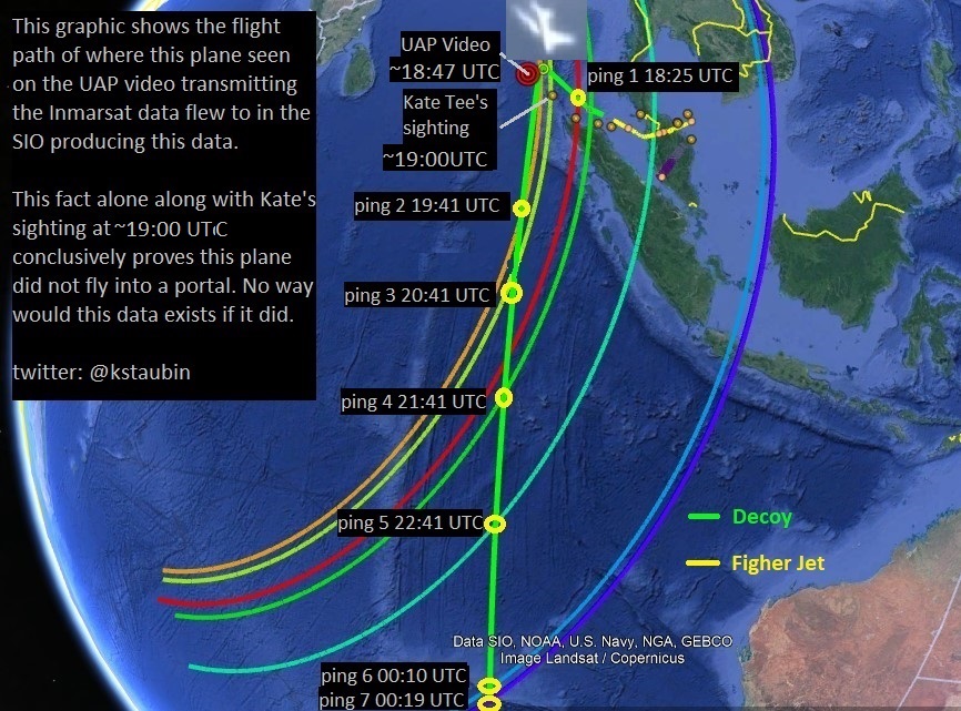
I believe the hijacking of MH370 was a sophisticated multi-Government covert military hijacking involving the use of a second aircraft, a UAV B777 decoy, to create false Inmarsat satellite data to mask MH370's actual flight path and confuse and deceive experts. They also used a fighter jet to spoof the PSR radar data as well. I believe the objective of the mission was to retrieve sensitive stolen military cargo that was on-board that plane. Here is a link to this diversion theory.
MH370: The Unspeakable Truth.

Conclusions:
Based on these eyewitness reports I am convinced that MH370 flew west to the Maldives, made two landings, and then was ditched in the Andaman Sea. I believe it's wreckage will be found somewhere downstream from where this satellite image off of Northern Sumatra was taken. The radar and Inmarsat data were created with decoys which is why that data is in error and it is the witnesses who are telling us the God's honest truth.
Ken S
Twitter @kstaubin
Footnote:
Philip Wood Photo
This black dark image was allegedly sent from passenger Philip Wood while in captivity at Diego Garcia documented in this report by freelance journalist Jim Stone. Initially this story was debunked because the Inmarsat data proved this plane could not have flown to Diego Garcia. So it was dismissed as a hoax with some saying the EXIF data was edited. It is true that the EXIF data contained in an image can be modified but there is no proof that this was done to this image. It is my belief this story is true.


I believe this sighting by Mike Mackay on an oil rig in the South China Sea could not have been that of MH370 because he was simple too far away and his sighting was sometime after 1:00 am (17:00 UTC) which was before this plane disappeared from radar and we know at this time where the plane was. I do believe he may have seen this mysterious plane that showed up on FlightRadar24 video just after 17:07 UTC flying directly towards his position on the oil rig at that time. If it was some advance military hypersonic jet it may have appeared as fireball coming at him because of it's engines.


just shut up with your crap dude
ReplyDeleteone more word from you know what happens next
ReplyDelete