MH370: Stop Blaming the Data.
Last Updated: Nov.25th, 2023
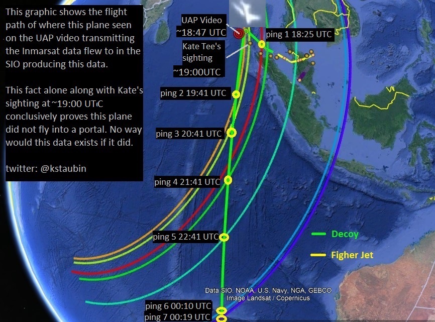
These UAP videos are believed to show the plane, believed to be MH370, that was transmitting this Inmarsat data on the evening this plane disappeared in the Andaman Sea on March 7th, 2014 UTC. See my previous research here.
The Inmarsat Data
Since the Inmarsat data was released back in April 2014 the provenance of this data has been questioned and contested. Many skeptics believe this data was somehow fabricated or manipulated by someone, somehow, to deceive investigators and the public. Others, such as myself, believe the data is completely authentic data but was being spoofed from another aircraft (decoy) to also mislead investigators, while there are those who believe the data is also authentic and believe it was not spoofed and was being transmitted by MH370 which most experts believe is the case.
The subject of this Inmarsat data being fabricated or manipulated by someone has been debated for years. When you know that this data was being downloaded onto multiple databases in real-time at Inmarsat and then verified by the Inmarsat engineers as being valid authentic data transmitted from an aircraft it's hard to imagine anyone could have modified or fabricate multiple databases in real-time. It's also hard for me to imagine that some engineer who works for Inmarsat is part of some grandiose conspiracy to deceive the public. There is just no realistic way this data could have been fabricated in real-time on multiple databases nor manipulated in anyway. The fact that this data seems to contain some corrupted data in it lends heavily to the belief this data is authentic.
Once you eliminate this possibility of the data being fabricated or manipulated you are left with valid authentic signal data that seems to indicates that data was being transmitted from MH370 because each data packet contained MH370's unique AES ID 35200217.
Although the BTO/BFO data is ambiguous data which does not give us precise location of the plane we can glean from the BTO data how far way this plane was from the Inmarsat subsatellite position on earth at the time of each ping. This math is just simple trigonometry based on the time delay of the signals and internal delay of equipment along with the speed of light which these RF signals travel at. The only way to increase or decrease the time delays is to move further away or closer to the satellite. You can't easily fake this.

What is certain from this BTO data is it tells us that this plane that was transmitting this data was somewhere along these ping rings at these times and that we can say this with relative certainty.


This is why I believe the last 7 pings are different from the rest of the Inmarsat data because this part of the data (18:25 -00:19 UTC) was being transmitted from a decoy using the same AES ID 35200217 as MH370 and had it's ACARS disabled in order not to give away it's exact position which is why no ACARS data was received during this time period just pings.

Since this data was also used to help prove the UAP videos were real by telling us the correct time (18:40 UTC) this plane was turning at those video coordinates this fact alone should also tell you that this Inmarsat data is valid and authentic data. If this is the case then this data is also telling us the portal in these UAP videos must be fake because this data tells us this plane flew for another 5 hrs 39 mins into the SIO after it turned at 18:40 UTC. You can't just ignore or throw out the rest of this data because you see the plane vanish in a portal in the video. You seriously have to question your theory if it contradicts this Inmarsat data and you are basing your theory on graphical pixel data that can be easily edited and fabricated. Think again!
Whether you believe this plane that was transmitting this Isat data in the UAP video was MH370 or a decoy, as I do, what is certain is that this plane ended it's final transmission along that 7th arc at 00:19 UTC and it did not vanish into a portal. Like Inmarsat said, "The data is fine providing it was not spoofed."

The graphic shows the approximate flight path (green track) of this plane (B777 decoy) that transmitted this Inmarsat data. It is my belief, based on this witness data, that MH370 flew west at low altitudes evading radar towards the Maldives and this plane in the UAP video that was transmitting this Isat data was just a decoy.
The Radar Data
This is another piece of data that has been hotly contested over the years and rightfully so. The RMAF radar story has changed three times. First they said the plane was detected near Pulau Perak at 18:40 UTC and then later retracted this story. They then said the plane headed west and then turned north/west which was later in 2015 revised to the current radar data we have today showing the plane made last contact at 18:22 UTC flying past Penang and up the Straits of Malacca.


The AFB Butterworth is an Air Force Station of the RMAF, and headquarters of the Five Power Defence Arrangements Integrated Area Defence System (HQIADS). Hard to believe that such state-of-art air defense system would have such a huge calibration error in their radar system on the night one of their passenger jets disappears. It should be noted this base also has RAAF personnel as well.
Since the RMAF has shown us no proof this altitude/speed data is significantly in error then we should assume it's valid data and if that is the case then this plane was most likely a fighter jet than a B777 because we know B777s cannot fly higher 44,000 ft.


It is my belief the first half of the radar data was created with a fighter jet (yellow track) and the second half was created from a B777 decoy (green track) that transmitted the misleading Isat data. MH370 (red track) flew west towards the Maldives evading radar which is based on this witness data.
ConclusionsOnce you understand that both the radar and Inmarsat data are real authentic data with a marginal error that was not fabricated nor manipulated in anyway then most likely if this data is in error and MH370 did not crash in the SIO it will be because decoys created that data and not because the data itself is in error or was fabricated. One thing is for sure is that whatever plane transmitted that data it ended it's final transmission along that 7th arc. What is also clear from the Inmarsat data is that if this plane in the UAP videos is the plane that was transmitting this Isat data then this plane did not vanish into a portal and so that part of the videos is a VFX hoax. I see nothing wrong with this radar and Isat data but rather only our assumptions are wrong. So stop blaming the data.
Ken S
twitter X : @kstaubin
References:
Inmarsat Signal Data (unredacted version)
Malaysian released RMAF PSR radar data
SAFETY INVESTIGATION REPORT Issued on 02 July 2018 MH370/01/2018


Comments
Post a Comment