How Was the Inmarsat Data Spoofed?
Here is one possible way a very sophisticated, state-sponsored hijacker, with deep pockets, and the willingness to scrap a million dollar aircraft, could have spoofed the Isat data, and radar data, creating the perfect MH370 data illusion.
The Inmarsat data that was supposedly transmitted by MH370 was sent to the satellite via an Airborne Earth Station (AES) on-board MH370 in which this system contains a Satellite Data Unit (SDU) that contains a unique identifier code (AES ID) which tells Inmarsat from which aircraft the data is coming from. Each SDU has it's own unique identifier code (AES ID) and each data packets sent out, or recieved, through this system contains this unique identifier code so Inmarsat can tell from which aircraft it was transmitted from.
Click on image below for more info on this AES system.

According to satellite industry expert Mike Exner, "The address is not specified in any SS memory. It is specified by 24 jumpers in a connector, soldered in.".
So a simple re-wiring, or modifying of jumpers, on a 24 jumper pin connector on the circuit board of the SDU will change the AES ID for that aircraft's unit. If you are on-board another aircraft (decoy) with the same AES equipment you can simply re-wire the jumpers on this SDU connector to match the wiring of another aircraft's (i.e MH370) unit . By doing so this AES unit will transmit signals using the same ID. So long as only one unit ( with the same ID) is operated at any giving time on the Inmarsat network there will be no network error and Inmarsat will not be able to distinguish the difference between the two signals and would be fooled into thinking the signals coming from the decoy are coming from MH370.
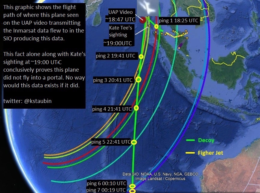
What we are seeing in the Inmarsat logfile are all the signals that were transmitted that day using that AES ID 35200217 which experts believe all came from MH370. However if a decoy was using the same ID as MH370's unit we would never know by looking at this data that it was being spoofed. I believe the fact that the last 7 ping signals do not have any data contained in them is an indication that this part of the data was coming from another aircraft who had it's ACARS shut-off in order not to give away it's exact position. This is why MH370 did fly to the Maldives and why the Inmarsat data is giving us the wrong location. Inmarsat themselves have said publicly the data is fine so long as it wasn't SPOOFED!
The Spoofed Data
Malysian Government Inmarsat signalling log


If you look at the Inmarsat data there seems to be a distinct change in the data after 18:25UTC. At the beginning of the flight upto 18:05 UTC, when the AES unit on MH370 was believed to have been turned off, the data contained user data (ACARS) that was being regularly transmitted. After 18:25 there was only handshakes being transmitted hourly with no user data this could have meant that this data was being transmitted from another aircraft which had it's ACARS switched off or disconnected.
Once MH370 AES unit was turned off sometime after 18:05 UTC it was never turned back on. What happened at 18:25 UTC is the decoy AES unit was turned on, with no USER data (ACARS) being sent, transmitting the same AES ID as MH370. Perfect deception fooling Inmarsat into believing this part of the data was coming from MH370 but when in fact it was being transmitted from a decoy.


The fact that this Inmarsat data contains corrupted data in it is a strong indication to me, that the data is authentic and was transmitted from an aircraft. However this corrupted BFO data tells us nothing useful about the motion of the aircraft on these time events.

Radar data
Another advantage of using this Isat spoofing method is the decoy can also be used to produce false and misleading radar data and make us all believe MH370 flew like this over the Malaysian pennisula when it fact this plane was the decoy.

This excerpt from Victor Iannello report seems to suggest that the crossing radar tracks maybe from two separate aircraft's.
"The path is assumed to follow a trajectory towards BITOD at the last recorded ground speed of 473 kn until a sharp turn commences at around 17:22:52. The military data show an impossibly steep turn that would indicate that the graphical representation in the figure is not accurate or the radar data has been misrepresented. It is possible that the sharp radar track is actually crossing radar tracks from two separate aircraft. These hypotheses merit further investigation, and will be the subject of future work."
Here is a link to his report https://drive.google.com/open?id=0B35tmLZHg1FEMWV6R0M5Z1k3Zm8
Here is another excellent report by Victor Iannello about the radar data seriously questioning the validity of this data and it's interpertation by the Malaysian Government: https://drive.google.com/open?id=0B35tmLZHg1FEZXBWZ3BZdVdxcjA
John's story: A not-yet-known ATC witness report suggests there were TWO AIRPLANES #MH370
Inmarsat data
By using a decoy like this to create both false and misleading Isat and radar data you can make all the experts in the world believe MH370 crashed in the SIO somewhere along this illusional 7th arc, while MH370 actually flew somewhere else, at low altitudes undetected by radar, thus creating the perfect deception.

Download Google Earth 3D Model

. Bobby Ulich Addendum #4 - MH370 Contrail Data and a New Route Fit
Impact Location
Once the false and misleading radar and Isat data has been created you can just crash the decoy plane as far south in the Southern Indian Ocean into the Antartica Circumpolar Current and watch it vanish.

LANL hydroacoustic report.
Notice how well the flight path to this possible impact sound location aligns perfectly with the location of the linear contrail seen in previous satellite image taken on March 8th in SIO. This is a strong indication that these two sets of data are connected and that some airplane did indeed travel on this flight path on March 8th, 2014 in this area of the Indian Ocean.
The fact that there are 3 sets of data (Isat, imagery, and acoustic) which converge in this area and seem to indicate that some plane, like a B777-200ER, crashed down here, is justification alone, in my opinion, to have this area searched.
If this is where the Isat plane did crash then very likely it's a decoy because all it's debris would very likely drift east towards Southern Auistrlia and nowhere near Africa.

Click on image above to see animation of this drift model.
Debris piece found on Kangaroo Island in Southern Australia which I believe is a piece of this decoy aircraft.


What is particularly interesting to me about the discovery of this piece of aircraft debris is the timing of it's discovery.
The piece was found by this guy Samuel Armstrong in June 2016 and he says it could have been lying there for upwards of 7 months.
if his statement is true then this piece may have washed ashore some 19-27 months after MH370's disappearance which indicates to me it could very well be associated with this debris field spotted in the SIO which I believe show pieces of an aircraft like a B777-200ER.
Satellite Imagery: http://www.thehuntformh370.info/.../possible-mh370-debris...
Based on this imagery data location I created this SIO drift model to predict where aircraft debris from this area would show up and at what time after the event it would take to get there. Listen to this video and the comments made by Oceanographer Jochen Kaempf about the possibility this piece may have originated in the SIO
The drift model (above) shows it would have taken about 16-20 months for debris from this area (~43S) in SIO to make landfall towards Kangaroo Island in southern Oz.
BTW I predicted this, based on this drift model, that debris from this area in SIO would show up in Southern Australia around the end of 2015 before the piece was discovered.
So I am convinced this piece of aircraft debris found in Oz is related to this aircraft debris field in SIO which confirms to me that this debris field seen in the satellite imagery is from an aircraft.
If this debris field is from an aircraft then very likely it's from the plane that transmitted the Isat data and this plane is not MH370....IT'S A DECOY!
I am hopeful in the next few months we can find absolute proof of this if Ocean Infinity will scan further south as indicated in this blog and find the wreckage of this plane.
Why is military debris showing up in Australia?
Hmm, a "military aircraft" ?? What if the decoy aircraft is a military aircraft? One that has an AES unit and can transmit and SPOOF Isat signals. I wonder if this "military aircraft" has a similiar airframe to a B777-200ER?
Satillite imagery data


Reverse Drift Analysis based on MH370 debris found in Africa
My reverse drift study: The Location of MH370 - A Reverse Drift Study Based On Debris Found

If MH370 crashed up here then what plane crashed in the SIO that transmitted the false and misleading Isat data?
Based on this reverse drift study I did using Ocean tracking buoy data from the website www.adrift.org.au
I was able to compile this composite reverse drift model based on the location of 30+ debris pieces found in Africa which are believed to be from MH370. This graphic shows that this most probable place in the Indian Ocean where all this debris in Africa originated from is close to the Equator near Indonesia. The results of my study are consistent with other reverse drift studies conclusions done by Meteo France, Geomar, and Brock McEwen's.
If these scientific studies are correct, and MH370 crashed nowhere near the 7th arc, then these scientific studies lend great credability to the possibility the Inmarsat data was spoofed in some way. Is this why the French Government have not released their reports yet?
Article by Jeff Wise: French Judiciary Report Raises Fresh Doubts About MH370 Debris
"After running hundreds of thousands of simulated drift trials under varying assumptions, Daniel concluded that if the piece floated as its Lepas population suggests, that is to say submerged, then it couldn’t have started anywhere near the current seabed search area. (See chart above.) Its most likely point of origin would have been close to the equator, near Indonesia. His findings in this regard closely mirror those of Brock McEwen and the GEOMAR researchers which I discussed in my previous post.

Geomar reverse drift study performed on the Reunion Island MH370 flaperon debris piece.
Article by Jeff Wise: MH370 Debris Fouling Supports Spoof Scenario
FO's Cell Phone Data
From Factual Report (30 July 2018) p66 section 1.1.5

What these test results prove is that it is most likely MH370 was flying at low altitudes, below 8000 ft, at time of connection (1752:27 UTC 0152:27 MYT), for a cell connection to be likely. This could mean that these witness reports of a low flying aircraft could be true and most likely this plane was MH370 evading radar detection flying at low altitudes.
The test results also prove that there is no way the plane seen on radar (green flight path) could possibly be MH370 because it was flying at too high of an altitude(44,700 ft) around time of connection (1752:31 UTC 0152:31 MYT): for this plane to have been the source of that cell signal. IMPOSSIBLE!

"Once you eliminate the impossible, whatever remains, no matter how improbable, must be the truth." ---- Arthur Conan Doyle
It is not "Rocket Science" to understand how easily and why this may have been done.

Conclusion:
Maybe this is why the Ocean science and reverse drift studies performed on MH370 debris discovered in Africa seems to indicate that MH370 did not crash in the SIO and nowhere near the 7th arc where the Isat data indicates it did because the plane that transmiited that data was a decoy. Maybe someone from the ATSB should get off their asses and go interview that fisherman in the Maldives and all those other witnesses who saw a low flying passenger jet that day. This is what the Inmarsat data is, it's just an illusion, a distraction, a smoke and mirrors show, created most likely by a state sponsored hijacker with a decoy, to keep us distracted from the truth.
Ken S
email: kstaubin@hotmail.com
Twitter @kstaubin


Comments
Post a Comment