The MH370 UAP Satellite Video Is Not a Satellite Video!
Updated: Oct. 7th, 2023
As a follow up to my previous post I did earlier last month on this subreddit about my video analysis of these UAP videos essentially proving that the videos are real and were filmed on March 7th, 2014 , around this time (18:40 UTC) at that location indicated in the video, I would like to point out some further details that I have learned from my analysis.
1- There is no way possible that the camera that took the sat video was either north or east of this video coordinates ground track because it would mean the camera was panning right to left unlike the video. For the camera to have been panning left to right like the video the camera would have to be to the west or south of this ground track.

Cameras Pan and Tilt Angles.
2- If the camera were in the north we would see the camera tilting upwards rather than downwards like in the video. If the camera were to the east the camera would be only tilting downwards towards the end of the video . The camera in the video tilts downward at the beginning and then pans left to right.
3- Based on further analysis and cloud comparison between both UAP videos and the NASA satellite image I am certain the camera was to the west of these video coordinates. The clouds don't lie. The only way to have this view perspective of the clouds is from the west looking east.

Satellite Video Camera Angle
Based on analysis the NASA satellite image the clouds tops were mostly below 5200 ft (1600 m) and I believe the plane was still flying at its last recorded altitude at 18:22 UTC on PSR radar which was 29,500 ft which would explain why we see the contrails.

MH370 UAP Satellite Video Correct Perspective.
Only this view perspective shows the plane heading south which is consistent with the Inmarsat data as well as the witness sighting of Kate Tee' who saw a high flying plane flying by her at ~18:53 UTC from north to south.

Kate Tee's sighting location.
I do not know as of yet what drone/craft/balloon was able to hover at these high altitudes, remain virtually motionless and take this stable steady panoramic stereoscopic pseudo-color IR video. The reason this is referred to as a satellite video is because it was downlinked and recorded from this relay satellite NROL-22 that was re-transmitting the video signals from the drone which is why this satellites name appears in video.
A pair of synchronous orbiting satellites are not the only way to have stereoscopic IR video you can do this with a drone with 2 FLIR pods spaced apart mounted on a drone like the MQ-1C Gray Eagle Predator that has two under the wings. The advantage of drones in aerial reconnaissance is they can loiter in one area longer and can capture greater details than any satellite because of their lower altitudes. Check out this video on ARGUS Autonomous Real-Time Ground Ubiquitous Surveillance.
Read this article on this 3D PluraView software used by the U.S, military for stereoscopic imagery video which in an addition to being used in geospatial intelligence (GEOINT) satellite imagery it is also used with FPV reconnaissance drones like the MQ-1C Gray Eagle Predator. Stereoscopic imagery can be achieved from a drone and not only from two synchronous satellites.
From article " Real-time display of stereoscopic video images, first-person view systems (FPV) for reconnaissance drones or remote-controlled systems,"

MQ-1C Gray Eagle Predator
I believe this is the drone MQ-1C Gray Eagle Predator which took the UAP FLIR video and was flying at its maximum altitude 29,000 ft. just 500 ft below this plane.

Satellite positions (Note USA-229 is east of coordinates)
The satellite USA-229 could not have taken this video it was moving too fast (890 Km/min) and would not have had the same view perspective from the east panning right to left rather than left to right like the video. This satellite video was not taken by a satellite nor a conventional drone nor aircraft either this drone was something else.
I am sorry if I am bursting your bubble with this USA-229 theory but trigonometry and data/imagery analysis debunks this theory. It does not mean these UAP videos are not real it just means it wasn't a satellite that took that video. Trigonometry and the clouds don't lie.

USA-229 Speed ~ 52,212 Km/hr (890 Km/min)
Was it some type of Black Project anti-gravity drone we don't know about?

TR-3B
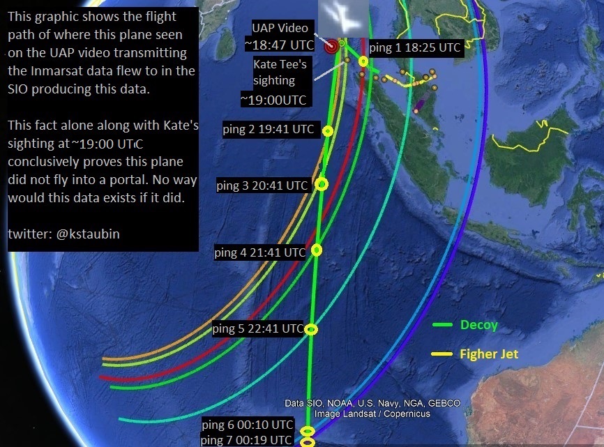
I am 100% certain these UAP videos are real and authentic (except for portal VFX). The clouds are real, the plane is real, I believe the orbs are real, but if this is the plane that transmitted the Inmarsat data the night MH370 disappeared, as we believe, then if this plane went through a portal the last 6 Isat pings of the Inmarsat data would not exist. Since they do exist, and both possibilities can't be true, then there is no way this plane went through a portal, More likely the hoaxers had a pretty good VFX team than this advanced teleportation technology that's why the Inmarsat data last 6 pings exists. This is why I believe the portal is fake and is just an added VFX but everything else is real.

Inmarsat BTO Data: After turn at 18:40 UTC the plane flew until 00:19 UTC another 5 hrs 39 min transmitting 6 more pings.
The UAP sat video was not taken by a pair of satellites (USA-229) flying at 890 Km / min east of the video coordinates. Whatever drone/craft/balloon that took this UAP sat video it was to the west of the video coordinates and was able to hover at high altitudes and take steady panoramic stereoscopic pseudo-color IR video. There is no easy answer here. I'll just leave it at that.
THIS IS NOT OBFUSCATION, THIS IS THE TRUTH!
Here's where the UAP video plane decoy ended up.


Ken S
Twitter: @ kstaubin
.


This comment has been removed by the author.
ReplyDeleteThere are some people who claim that when the cursor moves in the video the coordinates changes suggesting that coordinates are being changed by the cursor. However at the beginning of the video, around the 7 second mark, you can see the cursor moves but the coordinates don't change and then only change when the camera or video frame start to move. These facts tell me that the mouse or trackball that is controlling the cursor is also controlling the camera but only when the left mouse button is pressed down he can then move the camera or video frame by simply dragging the cursor. The video coordinates always indicate where the center of the video frame is pointing to point X, Y on earth. The cursor only affects the coordinates when it's moving the cam or video frame around with the left mouse/trackball button selected otherwise it can move freely around the screen and has no effects on the coordinates. I think this is why we are getting these conflicting results.
ReplyDelete