Why do these MH370 UAP Videos matter if they're a hoax?
Why do these MH370 UAP Videos matter if they're a hoax?
by Ken S @kstaubin on X
Last updated June 1st, 2024
This is a question I get asked alot from people on X. I have to acknowledge that this a valid question to ask since I do believe myself these videos are a hoax in the sense that this plane never teleported into a portal. I am pretty certain that this aspect of these two videos is nothing other than an added shockwave VFX stock asset from the 1990s Pyromania! Pro (VCE)(1997) CD-rom based on my own analysis, and those of others, and the fact that MH370 Inmarsat data that was being transmitted we believe from this plane in the UAP videos had to have flown for another 5 hours and 30 mins after it made that turn in the Andaman Sea that night so no way did it go through a portal if that Inmarsat data is authentic and these videos are real footage of that plane.
Video courtesy of @cryshlee on X

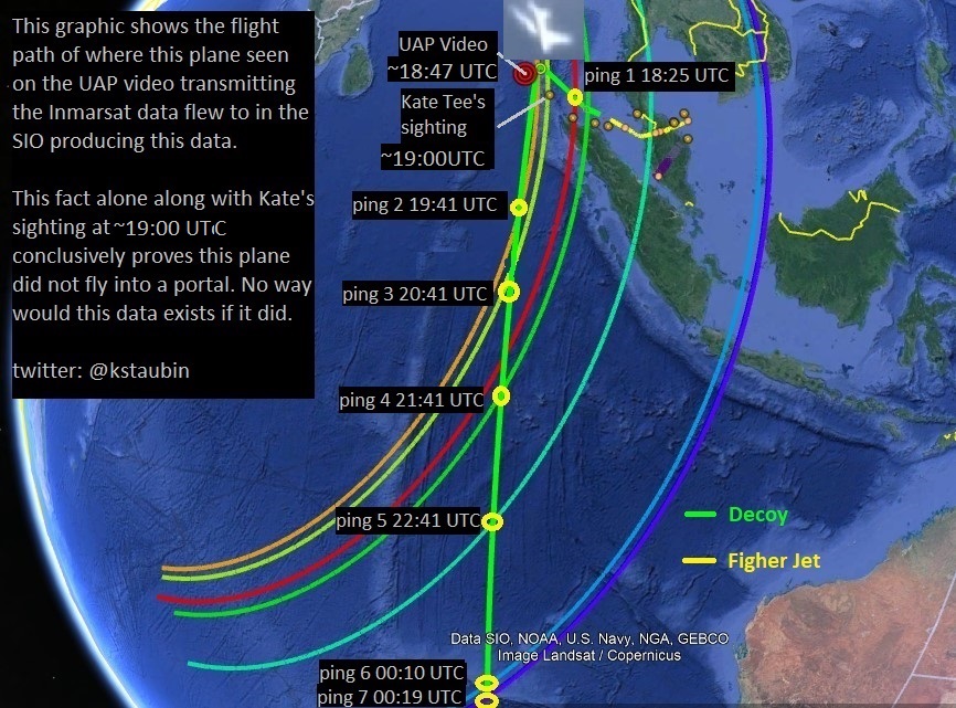
Predicted Flight Path (green track) of the plane transmitting this MH370 Inmarsat Data showing these 7 Burst Timing Offset (BTO) ping arcs.
The main reason I am interested in these videos from the beginning when I learned of the coordinates in the videos was the potential that these videos could be actual drone footage that was taken on March 7th, 2014 in the Andaman Sea and could be showing us MH370. This possibility started to intrigue me and made me take these videos more seriously. I started to theorize that if these videos were real footage that was edited with VFX but this plane is real and that plane is MH370 then this plane should be turning at those coordinates in video at somewhere around 18:49 UTC in the Andaman Sea on March 7th, 2014.

FLIR Video
Based on my analysis of the both videos footage I am convinced that both videos are actual filmed footage and not a 3D CGI animation. The main reason I believe these videos are actual filmed footage of a plane is because of the following evidence.
This video (below) shows that the plane in video is real. We can see between these two frames how the engine exhaust temperature (yellow/red dot) has increased in temperature causing the ambient air to warm up causing the outer color surface temperature of the plane to change in color as well as making the contrails to change in density and shape as well.


The plane may have been removed from video using more sophisticated VFX methods like this (see below) but why is that mask there? Sloppy edit work? I believe everything in this FLIR video is real, including the orbs, except for the VFX shockwave that was added to the video.
I reject the theory this is random noise or something natural like clouds. If it was random noise it should not be moving across the screen like that and it's too geometric in shape to be something natural in my opinion like clouds, besides the clouds that night were below 5250 ft and this plane would have been flying above ~26,000 ft because of the contrails. I also reject the theory this is a cold air mass its too geometric in shape to be that either. There is also no logical reason why this dark mask would be added into a fake VFX production or CGI animation.
This dark mask appears in approx 12 frames in video and moves towards the right out of frame as seen in this video. I believe the orbs are real and only they vanish into thin air and the plane keeps flying south which is why they needed to remove only the plane from frame after the fake shockwave was added. Physically nothing happened to the plane except it may have gotten blown off course slightly at time from a strong gust of wind as the orbs vanished.
Here are some other reasons why I believe these videos are using actual filmed footage. The fact that both videos appear to be in perfect sync and the contrails seem to be also in perfect sync with plane while the camera shakes because of the turbulence as the drone passes below planes contrails. This would be difficult to achieve with using only 2D VFX software. Ideally a 3D animation would have to have been created in order to get this kind of accurate synchronization between the videos and plane.


I believe everything in this FLIR video is real except the VFX shockwave.
It is more likely in my opinion this is actual filmed footage than this video being a complete CGI/VFX creation. I doubt very much some individual dreamt this all up in his head just to create a realistic hoax like this.
NASA Satellite Imagery
Once I established these facts I then looked into satellite imagery data taken that night in the Andaman Sea to see if I could spot any similarities in the cloud patterns. We found this satellite image from NASA WorldView that was taken by the satellite SUOMI-NPP on March 7th, 2014 showing the clouds patterns that were in that area that night at 18:54 UTC. What I found between the clouds in the FLIR video and the clouds in this NASA satellite image were 18 points of similarity which leads me to say with confidence that these are the same clouds in both images and thus this footage was filmed on March 7th, 2014 in the Andaman Sea just as my analysis of the Inmarsat Data predicted.


NASA WorldView Satellite Image taken March 7th, 2014 at ~18:54 UTC shown the actual clouds that were at those video coordinates that night.

This image shows the orbital track of where the satellite SUOMI-NPP was on that date March 7th, 2014 when it took this satellite image between 18:54-18:55 UTC.
Satellite Video
With regards to the satellite video I believe this video was not taken from a satellite at all but rather it was taken from another drone and the video has a false cloud background in it. This is how you can get this kind of video image resolution yet appear to make the camera seem stationary in the sky. It is also why the plane appears to some at lower altitudes because it appears to be a few thousand feet above those clouds.cumulus. This is another reason why I'm certain we know this is a false background because the cumulus clouds should be much lower in the sky(below 5250 ft) if those are contrails and this plane is flying above 26,000ft.
We know that these are contrails because smoke and fog do not show up in IR video and would dissipate much sooner than contrails which are comprised of ice crystals that do reflect IR radiation. These are definitely contrails and not smoke trails coming from both engines. This plane is not on fire and is most likely flying at altitudes above 26,000 ft, where the air temperature is below -36C.


Video courtesy of @cryshlee on X
I believe the plane, the orbs, and the coordinates are real in this video but not the clouds nor shockwave which are VFX.
The reason a false background was used in this video was to avoid masking. The VFX artist had to add a fake shockwave to actual footage of the plane and then make the plane disappear in frame. A simple video editing technique using a Video Background Editor like this one can allow you to swap out the background in any video. By doing this when you want the plane to vanish in video you simply switch to the false background and voila the plane is gone. This technique avoids the need to do masking and I suspect this method was used in this video because they would have had a lot more frames to edit in this video in both left and right stereoscopic videos. In the FLIR video there was only about 12 frames to edit so he did not need a fasle background in that video and chose masking instead.

I am pretty certain it was the people who filmed this drone footage, the US Gov,/CIA/US DoD.
Why do people create hoaxes? To makes us believe in a reality that does not exist (like teleportation) and to obfuscate from the truth about MH370. I believe the CIA using these fake accounts like these on social media created these hoax videos to keep us distracted from the real truth about what they did to that plane and make us believe aliens teleported this plane into another dimension and that's why were never gonna find it.
Orbs
I still believe the orbs are real because I see perfect synchronization between both videos and that would be difficult to achieve with just 2D VFX editing. I believe the orbs are the reason this video was created in the first place and the original footage was captured on a Citrix session during a covert military operation to hijack MH370. I believe the orbs only scanned this plane and then vanished leaving the plane alone to continue flying south, As unbelievable as that sounds it would not be the first time these orbs show up during US military activities and installations. Go check out wartime stories on YouTube.
Conclusions:
If the videos were taken on that night in the Andaman Sea then I am certain this is the plane that transmitted this Inmarsat data that night MH370 disappeared because there was no other passenger jet that we know of that ever flew in that part of the Andaman Sea where there are no other air routes but MH370 that night.
I am certain that both of these UAP videos are actual filmed drone videos that were taken on March 7th, 2014 in the Andaman Sea and the plane in these videos is indeed the plane that was transmitting this Inmarsat data the night MH370 disappeared flying out to the Southern Indian Ocean (SIO) being filmed by two US military drones. If this is the case then the US government must know hell of a lot more about what happened to MH370 than they have stated so publicly and very likely MH370 was a conspiracy and massive cover-up and that's why these hoax videos matter. .
Ken S @kstaubin on X
Here is a link to my YouTube Channel on my MH370 Theory and Research.


Hey! HUGE fan of your MH370 videos! Why did you delist them???
ReplyDelete